The Northern region is experiencing continuous heavy rain over several days due to the influence of a low-pressure trough combined with wind convergence. At the same time, the Southern region continues to witness thunderstorms after setting numerous rainfall records in July.
The National Center for Hydro-Meteorological Forecasting reported that on August 5, the Northern region and Thanh Hoa continued to receive moderate to heavy rainfall ranging from 30-60mm. Some areas may experience heavy rain exceeding 100mm per day, particularly in the northeastern border region where rainfall could surpass 120mm.
This marks the 8th day of widespread heavy rain in the North (starting from July 29). Rain has also expanded to areas from Nghe An to Ha Tinh, though in smaller amounts, typically ranging from 10-30mm.
On the night of August 5-6, the mountainous and midland regions of the North are expected to experience moderate to heavy rain, while other areas in the North may see scattered showers with thunderstorms. Rainfall is expected to concentrate in the afternoon and evening.
Mr. Vu Anh Tuan, Deputy Head of the Weather Forecasting Department at the National Center for Hydro-Meteorological Forecasting, stated that the ongoing heavy rainfall in the North is due to the influence of the low-pressure trough, combined with high-altitude wind convergence, continuously supplying moisture.

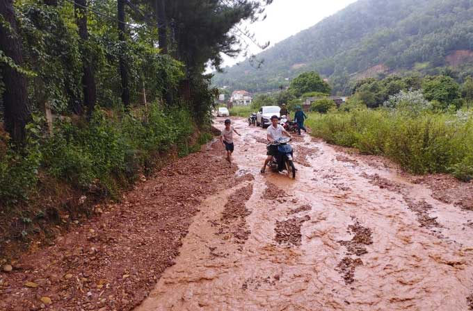
The heavy rain on August 4 caused a significant amount of mud to flow onto local roads in Phu Ninh village, Minh Phu commune, Soc Son, Hanoi. (Photo: Tran Thanh).
In the coming days, the low-pressure trough over the Northern region will remain active, and another low-pressure area is strengthening in the northeastern border region. This weather pattern is expected to persist from August 5-8 and then gradually move westward. This is why heavy rainfall in the North is expected to continue until about August 8.
Mr. Tuan mentioned that from now until August 8, the heaviest rainfall will still be focused in the Northwest and northern border regions. Many areas in the North are expected to experience widespread heavy rain. Rainfall amounts may be similar to those of recent days, posing a high risk of flash floods and landslides in mountainous areas.
Additionally, from August 5-7, the activity of the low-pressure area may cause thunderstorms and strong winds in many localities. Experts also warn that short-duration, high-intensity rain could lead to urban flooding.
Heavy Rain in the Central Highlands and Southern Region: Is it Due to El Niño?
Evaluating the weather in the Central Highlands and Southern region in recent days, Mr. Vu Anh Tuan noted that both regions have recorded substantial rainfall in July, a trend that is expected to continue in the coming days. The direct cause is the activity of the tropical convergence zone over the East Sea combined with the strong southwest monsoon.
“The second reason is the influence of El Niño. However, this is a significant weather phenomenon, and its effects usually have a lag time of about 2-3 months. Therefore, this is only an indirect cause of the heavy rainfall in the Central Highlands and Southern region in recent times,” Mr. Tuan commented.
Experts forecast that during the rainy season, the Central Highlands and Southern region will continue to experience many days of showers and thunderstorms, primarily in the afternoon and evening. The total rainfall in the region in the first half of August is expected to be lower than in the latter half.
As for the provinces and cities in the Northern region, there will still be sunny days interspersed with periods of rain throughout August. Meanwhile, the Central region is expected to continue experiencing hot weather until around mid-month, after which temperatures may gradually decrease.
|
Many areas in the Central Highlands and Southern region recorded historic heavy rainfall in July According to data compiled by the National Center for Hydro-Meteorological Forecasting, in July, the Central South, Central Highlands, and Southern region experienced total rainfall significantly above the average of previous years, increasing by 50-100%, or 1.5-2 times compared to the same period. Notably, on July 29, the Southern region recorded four locations exceeding historical rainfall values: Con Dao (Ba Ria-Vung Tau), Can Tho City, Vi Thanh (Hau Giang), and Rach Gia (Kien Giang). In terms of total rainfall for July, the Central Highlands saw measurements in Dak To (Kon Tum) surpassing historical values, while the Southern region recorded eight locations, including: Binh Phuoc, Dong Nai, Binh Duong, Ba Ria-Vung Tau, Vinh Long, Can Tho, Hau Giang, and Soc Trang. In the Central South, Phu Quy (Binh Thuan) recorded a total rainfall of 364mm for the month, surpassing the previous record set in 1991. The area with the highest rainfall in the country in July was Phuoc Long (Binh Phuoc), which recorded nearly 950mm for the month, far exceeding the previous historical value (771mm) recorded in July 1997. |


