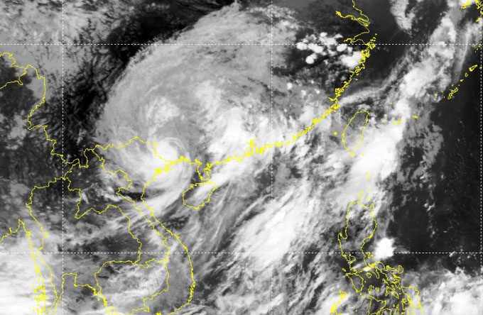
At 12 PM on July 18, Typhoon Talim was located 50 km from Mong Cai (Quang Ninh) with maximum wind speeds of 88 km/h, classified as level 9, and is likely to weaken into a tropical depression within a few hours.
The National Center for Hydro-Meteorological Forecasting reported that Typhoon Talim passed the Leizhou Peninsula (China) at 3 AM with maximum wind speeds of 117 km/h, classified as level 11. Over the past 9 hours, the storm has moved deeper into southern Guangxi province (China) and has weakened.
The storm is currently headed northwest at a speed of 20 km/h, expected to move deeper into Guangxi, approximately 60-80 km from the border with Quang Ninh and Lang Son, and is forecasted to weaken into a tropical depression at 4 PM near the Vietnam-China border. The tropical depression will then move deeper into the mountainous Northwest region and gradually dissipate.

The eye of the storm (white spiral) nearing the Vietnam-China border, noon July 18. (Satellite image: NHCMF)
The forecast from Vietnam today is consistent with reports from the U.S. Navy, TSR (University College London, UK), and Hong Kong. These agencies predict that the storm will enter Guangxi province (China), following the coastline, before moving approximately 60-80 km from the border with Quang Ninh and Lang Son, then into the Northwest region where it will dissipate.
Comparing the actual path of the storm with the two scenarios provided by the Vietnamese meteorological agency yesterday morning, the scenario with a 20% probability has occurred, aligning with the forecasts from international agencies. Consequently, the area and duration of rainfall have been narrowed compared to earlier predictions.
Today and tomorrow, the Northeast and Vietnam’s northern mountainous areas are expected to see rainfall of 100-200 mm, with some areas exceeding 300 mm. The Northwest region will experience 50-150 mm of rain, while the Red River Delta and Thanh Hoa will receive 50-100 mm, a reduction of two-thirds compared to yesterday’s forecast. Provinces such as Quang Ninh, Lang Son, Cao Bang, Ha Giang, Lao Cai, and Yen Bai should be aware of the risks of flash floods and landslides.
The waves in the Gulf of Tonkin are expected to reach heights of 2-3.5 meters; along the coast of Quang Ninh – Hai Phong, waves could be 1.5-2 meters high. There is a risk of flooding in low-lying areas along the coast, river mouths, and coastal erosion due to the effects of high tides, large waves, and storm surges expected on the afternoon of July 18.

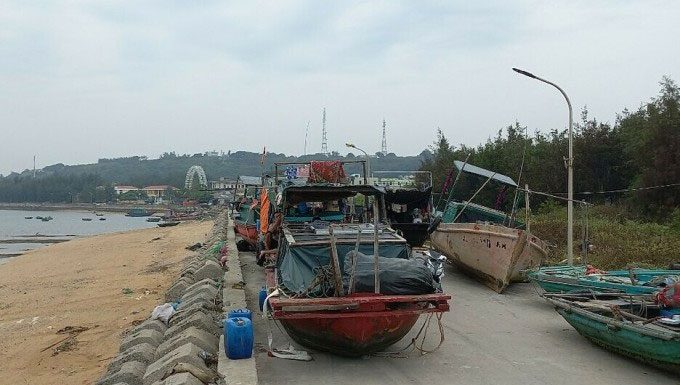
Co To Island (Quang Ninh) experienced light rain early on July 18. (Photo: Le Tan).
The pre-storm circulation has caused Bạch Long Vĩ Island (Hai Phong) to experience winds of level 7, gusting up to level 10; Cửa Ông, Co To (Quang Ninh), and Phu Liễn (Hai Phong) recorded gusts of level 6-7. According to local authorities, no damages have been reported in these areas.
About 60 km from the storm’s center, Mong Cai City (Quang Ninh) and Bạch Long Vỹ Island (Hai Phong) experienced light rain with cool weather. Government offices, kindergartens, local markets, and shops remain operational. Traffic on the Tan Vu Bridge (Hai Phong) and Bai Chay Bridge (Quang Ninh) is normal.
However, activities at sea and on beaches have been temporarily suspended until further notice from the authorities. The Got – Cai Vieng ferry terminal and the Rung ferry terminal have not resumed operations.
The three airports affected by Typhoon Talim are Van Don (Quang Ninh), Cat Bi (Hai Phong), and Noi Bai (Hanoi), which are currently closed. Fishing vessels along the coastal provinces from Quang Ninh to Thai Binh remain in safe harbor. Localities are on standby, anticipating possible flooding and landslides due to post-storm rains.
Typhoon Talim formed on a tropical convergence zone in the Northwest Pacific, and after entering the South China Sea, it moved primarily northwest, rapidly intensifying to a peak of 133 km/h (level 12) on July 17. Following Talim, there is a possibility of 2-3 more storms forming from this convergence zone, with one expected to enter the South China Sea in the next 4-6 days.


