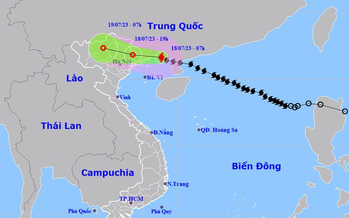
At 7 AM on July 18, Typhoon Talim was located 100 km from Mong Cai (Quang Ninh), with maximum winds of 102 km/h, categorized as level 10, and was expected to make landfall on the Vietnam-China border in four hours.
The National Center for Hydro-Meteorological Forecasting reported that Typhoon Talim crossed the Leizhou Peninsula (China) at 3 AM with maximum winds of 117 km/h, categorized as level 11, before moving onto the coast of Guangxi Province (China) where it continued to weaken.
The pre-storm circulation caused Bạch Long Vĩ Island (Hai Phong) to experience winds of level 7, gusting to level 10; Cửa Ông and Cô Tô (Quang Ninh) had gusts of level 6-7; and Phù Liễn (Hai Phong) experienced gusts of level 6.
The storm is moving in a west-northwest direction at a speed of 20 km/h and is expected to enter the Vietnam-China border by 11 AM with maximum winds of 88 km/h, categorized as level 9. By 4 PM, the center of the storm will be in northeastern Northern Vietnam, with winds diminishing to level 7 and weakening into a tropical depression. The tropical depression will then move further into the northern mountainous region and dissipate by early July 19.

Forecast path and affected area of the storm at 7 AM on July 18. (Photo: NCHMF)
Compared to the forecast from the previous afternoon, the path and intensity of Typhoon Talim have changed slightly. The center of the storm will skim past Mong Cai City (Quang Ninh), resulting in a narrower area of rain. In the Northeast and Viet Bac regions, rainfall is expected to be 200-300 mm, with localized areas exceeding 350 mm. In the Northwest, the Red River Delta, Thanh Hoa, and Nghe An, rainfall will range from 70-150 mm.
The Japan Meteorological Agency predicts the storm will make landfall on the Vietnam-China border but will shift slightly northward, with wind speeds remaining above 70 km/h as it moves inland. The Hong Kong Observatory also predicts a similar path, with wind speeds before landfall at 105 km/h, with the storm weakening into a tropical depression in Bac Kan Province.
The Gulf of Tonkin is expected to see waves of 2-3.5 m. Along the coastal provinces of Quang Ninh and Hai Phong, wave heights will reach 1.5-2 m. There is a risk of flooding in low-lying coastal areas, river mouths, and coastal erosion due to the combined effects of high tides, large waves, and storm surges (0.3-0.5 m) on the afternoon of July 18.

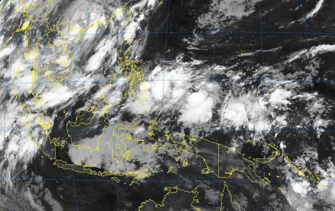
Satellite image of the convergence zone over the Northwest Pacific on the morning of July 18. (Photo: NCHMF).
Today, three airports directly and indirectly affected by Typhoon Talim, namely Van Don (Quang Ninh), Cat Bi (Hai Phong), and Noi Bai (Hanoi), have been closed. The evacuation of boats and residents in coastal provinces from Quang Ninh to Thai Binh has been largely completed. Localities are on standby, anticipating that post-storm rainfall may cause flooding and landslides, impacting vulnerable dyke systems.
Typhoon Talim formed in the tropical convergence zone over the Northwest Pacific, and after entering the East Sea, it primarily moved in a west-northwest direction, rapidly intensifying to a maximum speed of 133 km/h (level 12) on July 17. Following Talim, there is a potential for 2-3 additional storms to form from this convergence zone, with one expected to enter the East Sea in the next 4-6 days.


