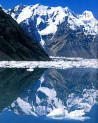
 Kyrgyzstan, located in Central Asia, is nurtured by towering peaks reaching up to 7,000 meters. The Inylchek Glacier holds an unexplained mystery that has persisted for a century: every summer, the Merzbacher Lake within it dries up completely for three days. Why does this happen?
These questions have lingered since the early 20th century when German geologist Gottfried Merzbacher discovered the lake in 1904, which was subsequently named after him. In an attempt to unravel the mystery of Merzbacher Lake, an international expedition led by GFZ Berlin embarked on a summer journey to the lake this year. For the first time, scientists are striving to answer this question.
The massive Inylchek Glacier stretches 65 kilometers, with two main branches converging 15 kilometers from the glacier’s terminus. At the junction of these two branches, at an altitude of 3,300 meters, lies Merzbacher Lake, which is 130 meters deep and partially covered by icebergs. Every year, the lake completely drains over three days, around early August.
The impossible happened. At 4 PM on August 6, 2004, Merzbacher Lake began to drain itself! This bizarre phenomenon occurs annually around this time. With its placid appearance, the lake’s frozen waters gradually descend into the depths of the Inylchek Glacier. Lower than 30 kilometers downstream, within hours, the vast valley becomes flooded. From a modest mountain river, the Inylchek transforms into a fierce ocean, overtaking the entire area. Over three days and nights, the lake drained 250 million cubic meters of water, leaving behind a somber carpet of massive ice blocks. By August 9, the water withdrawal was complete in the valley. The glacier ceased its transformation, and Merzbacher Lake was empty. What miraculous force allows this glacier-fed lake to drain itself in just three days? Where did the water go? How did the drainage occur? And how does the lake refill again?
July 19, 2004. Upon arriving in Bishkek, the capital of Kyrgyzstan, challenges became apparent. Serguei Dushavili, one of the expedition leaders, announced, “We may have to travel on horseback for four days if the helicopter is unusable.” Unable to leave behind the Russians in the group, despite there being only one helicopter in Kyrgyzstan, a massive MI-8 finally appeared to pick us up after two arduous days on rough roads.
We set up two camps, 20 kilometers apart: one at the foot of the glacier, where the Inylchek River begins, and the second directly on the river, facing Merzbacher Lake. In our daily radio communication, we referred to the two camps as Paliana and Basa. The glacier was divided into several sections from west to east, with each team responsible for studying areas near their camp. At this time, the lake was still full, as we had observed from the air that morning. It was indeed very full, according to pilots who frequently landed climbers at the foot of the 7,000-meter Khan Tengri peak. In July, Merzbacher Lake reached record water levels.
Each with a unique hypothesis
Each expedition is characterized by the weight of uncertainty before the mysteries of nature. Our expedition was no exception to this rule. We wanted quick answers after a few days on site. However, the expedition was scheduled for four years. The goal of this first year is to establish a network of GPS points to measure, using satellites, every movement of the glacier. Dr. Wasili Michaljow, the expedition leader, predicted, “We will probably have many answers in a few weeks. But for now, we should minimize our hypotheses.” Nevertheless, the hypotheses continued to pique everyone’s curiosity. At that time, Serguei Dudashvili presented his hypothesis:
There was no single hole allowing Merzbacher Lake to drain, but many openings were blocked by massive ice blocks. In winter, these ice blocks press against the bottom of many porous holes, acting as a natural barrier. This is why the lake stays full, as the “valve lids” remain closed due to pressure and low temperatures. When summer arrives, the water warms up and the large ice blocks begin to melt until – according to Serguei – they lose their adhesion and suddenly rise to the surface. This phenomenon corresponds with the sudden opening of the “valve lids.” Such a hypothesis can only hold if the lake’s water level rises downstream equally abruptly. Therefore, we must wait to uncover the truth.
July 28, 2004. Six days have passed since we arrived at Camp Paliana. We marked off a grid over an area of about 10 kilometers. The average altitude is 3,000 meters. For safety reasons, our camp is located on the west side of the Inylchek River, which forces us to wade through water to reach the glacier. The water temperature is 1 degree Celsius.
While we were installing markers in the glacier’s lower area, cave researcher Wasili Filipienko identified two massive caves. Less than 2 kilometers from the lake, these caves could be part of their drainage hydrological network. During the “warm” period, the melting and freezing water in these two caves, along with the lake threatening to burst at any moment, prevented scientists from exploring them. After two unsuccessful attempts to penetrate the caves, we had to give up. The cave research would have to wait until autumn.
August 1, 2004. Unfazed by the expedition’s anticipation, Merzbacher Lake remained full. Serguei suggested heading south. Here, the glacier widens to about 4 kilometers and is particularly chaotic. From our camp, it took three hours of walking to reach the secret area separating the lake from the glacier itself. We knew there were holes in this area, but no one had managed to reach them. What happens in this natural barrier? How does the transition between water and ice take place?
The simplest factor, and likely the explanation for the lake’s existence, is the uplift of ice from the southern branch of the glacier in this area. Instead of melting along with the northern branch in a perfect Y-shape, as is typical with most glaciers worldwide, this branch rises, forming an icy barrier that retains the water of Merzbacher Lake.
We never reached the southern shore of the lake. The closer we got, the larger the icebergs became, merging together and creating numerous crevasses. One thing is certain: this uplifted ice surface from the southern branch is the cause of the unique phenomenon of the lake draining. Without this anomaly, the lake would not exist. Over the past century, Merzbacher Lake has moved 2 to 3 kilometers downstream. The icy barrier is now very close to the junction of the two river branches, and the lake may disappear in the not-too-distant future.
August 3, 2004. The temporary expedition comes to an end. The lake remains full. I decided to stay alone until the lake drains. Not at Camp Basa, where observation is difficult, but in the valley, 30 kilometers below, where the water phenomenon would be spectacular.
August 5, 2004. Tatiana shared with me several signs indicating the lake has begun to drain. New water points have appeared in the riverbed. The flow of the Inylchek Glacier is gradually increasing…
August 6, 2004. At 4 PM. This time, the river’s volume is three to four times greater. The valley is flooded. The lake is definitely breaking down. Serguei’s hypothesis has been dismissed. The water flow has continued to increase for two days. It is clear that the opening of the “valve lids” did not occur suddenly. The melting of the ice plugs is gradually releasing the water from Merzbacher Lake, not the rising of the surface of the ice plugs.
Ultimately, to solve the mystery of Merzbacher’s drainage, we may have to wait a few more years…


