One of the most catastrophic floods in human history occurred in 1287 in Europe, claiming the lives of tens of thousands of people.
It can be said that the St. Lucia Flood of 1287 is one of the greatest disasters in European history. With over 50,000 deaths, dozens of villages erased, and geographical maps redrawn, this event was one of nature’s most furious tempests, highlighting the vulnerability of ancient coastal regions, Ancient Origins reported on March 25.

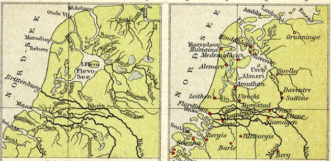
Map showing the development of the Zuiderzee in the Netherlands before and after the St. Lucia Flood. (Photo: Wikimedia).
For centuries, the Netherlands has been known for its low-lying position relative to the surrounding seas. This is why today, it has become a land of canals and islands. This coastal nation is gradually losing land, and if sea levels continue to rise globally, many areas may be permanently submerged.
The map of the Netherlands was not always as it is today. In the early Middle Ages, the country had a much larger land area exposed, and many villages existed closer to the sea. However, a catastrophic flood, caused by storm surges, permanently altered this landscape.
The St. Lucia Flood occurred on December 13, 1287, exactly on the day the Dutch celebrate St. Lucia’s Day. A violent storm coincided with high tide, resulting in devastating floods. Vast coastal areas were quickly engulfed by water, drowning villages and cities. Estimates suggest that around 50,000 to 80,000 people perished in this flood. Low sandy beaches and coastal dunes could not withstand the massive waves and easily eroded. Many lowlands were submerged. Residents of villages that were not swept away had to evacuate.
The floods brought chaos to the Netherlands. Cities that remained intact were now in entirely new locations due to the changed coastline. Water did not recede, creating several islands and lakes that still exist today. Most notably, the emergence of the Zuiderzee – a shallow bay extending 100 km inland. Previously, this area was just a small freshwater lake connected to the sea by the Vlie River. The St. Lucia Flood completely destroyed this river. This meant that the thriving trading ports along the river also declined.
After the St. Lucia Flood, the focus shifted to the IJssel River. New trading cities such as Zwolle, Deventer, Kampen, and Doesburg emerged here. A new trading port named Amsterdam began to thrive. Today, Amsterdam is the capital of the Netherlands.

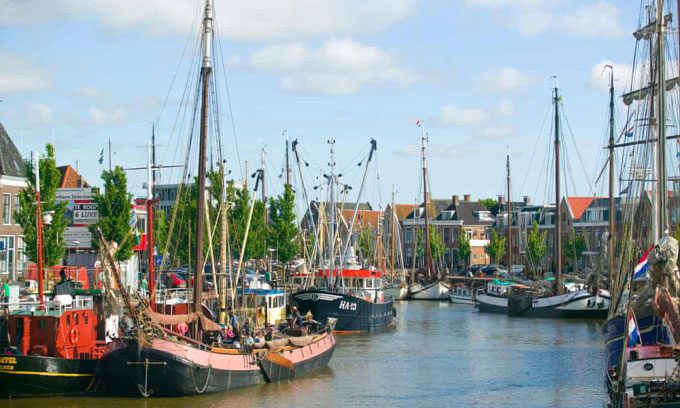
Harlingen, a city that was once inland, is now a port city in the Netherlands. (Photo: Uwe Moser Moser/Alamy).
In Frisia, a region neighboring the Netherlands, the devastation was also severe. Many small inhabited islands disappeared permanently, causing significant loss of life. The coastline shifted several kilometers inland. For instance, Harlingen, a city that was not coastal before the flood, suddenly found itself on the shore. After the flood, this city became a port. The nearby island of Griend, which had many residents, was severely ravaged, with only 10 houses remaining.
In addition to the Netherlands and Frisia, the coastal regions of Germany were also affected, with many villages in East Frisia disappearing forever and thousands of lives lost. Survivors witnessed the altered landscape, and their traditional way of life no longer seemed viable. Many fled inland, forced to start entirely new lives.
The North Sea region also did not escape the storm’s fury. The coast of England suffered heavily, and the maps of this area were nearly redrawn completely. The town of Old Winchelsea, once a bustling port, has now vanished forever. In the small village of Hickling, 180 villagers lost their lives. The trading port of New Romney abruptly became a town situated inland as the storm silted up the harbor, redirecting the nearby river approximately 24 km westward. The land in the town rose an additional 13 cm due to sediment accumulation.
In the town of Hastings, the storm caused half the cliffs to collapse, severely damaging the Norman castle. The town was no longer a bustling port as the narrow bay was wiped out by the storm. One of England’s major ports, Dunwich, began to decline rapidly during this period. The storm of 1287 caused coastal erosion and flooding, contributing to the decline of Dunwich as a leading coastal town. The town’s lifeblood river shifted several kilometers northward. Once home to over 3,000 residents, Dunwich is now just a modest village with 180 inhabitants.


