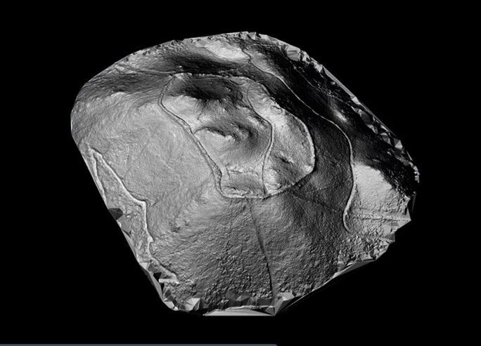
A LiDAR survey, a remote sensing method using lasers to detect hidden structures, has uncovered a massive fortress with 30 towers on a desolate hill in Spain.
According to Heritage Daily, the survey conducted by the University of Santiago de Compostela (Spain) in the region known as Castro Valente, an archaeological site located between the provinces of A Coruña and Pontevedra in Spain, has revealed a huge fortress dating back to the 5th to 7th centuries AD.
Archaeologists utilized LiDAR, a remote sensing technology that uses pulsed laser light to measure distances from the laser source to the ground, penetrating through covering structures like canopies and grass to create a 3D map of the landscape with concealed structures.

LiDAR image showing the existence of a ghost fortress on the hill – (Image: University of Santiago de Compostela).
Castro Valente was previously thought to be a fortified settlement from the Iron Age on a hill 400 meters high, first mentioned in 19th and 20th-century publications.
The new survey has unveiled something much more intriguing: a medieval ghost fortress covering an area of up to 12 hectares, surrounded by a defensive wall stretching 1.2 kilometers with 30 towers. The structural complex was built in a Roman style.
An on-ground survey confirmed that the walls were constructed using double-leaf bricks and varied in thickness from 2.4 meters to 4.2 meters. The survey also verified 6 above-ground towers among the 30 identified by LiDAR, along with a seventh tower that had been destroyed, leaving behind a charred remnant.
The research team believes they have identified several interior structures made from fragile materials and stones, including Roman roof tiles and small fragments of red pottery.
This study marks the first step in exciting further investigations to ascertain the true nature of the site; however, the remaining part of the fortress is currently threatened by the installation of 4 wind turbines, 6 electricity towers, and a transformer that is about to take place.


