Tropical Storm Maon, with maximum winds of 102 km/h, classified as a level 9-10 storm, is currently located to the east of Luzon (Philippines) and is expected to enter the South China Sea tonight.
The National Center for Meteorological and Hydrological Forecasting has stated that today the storm is moving northwest and will later shift to west-northwest at a speed of 15-20 km/h, heading into the northern South China Sea, marking it as the third storm of the year in this region.
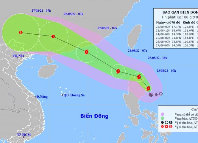
Expected path of Tropical Storm Maon, morning of August 23. (Photo: NCHMF)
By 7 AM tomorrow, the storm’s center is forecasted to be approximately 810 km northeast of the Paracel Islands, with maximum winds reaching level 10, gusting up to level 12. The storm will then move towards Guangdong Province (China), with maximum winds of 117 km/h, classified as level 10-11.
Starting this afternoon, the northern South China Sea will experience increasing winds from level 6 to 10, with gusts reaching level 12; sea waves will be as high as 5-7 meters.
The Japan Meteorological Agency reports that the storm is currently at 108 km/h and will enter the South China Sea early tomorrow morning, reaching Guangdong Province by August 25. The Hong Kong Observatory estimates the storm will enter the South China Sea with winds of 85 km/h, intensifying to a maximum of 110 km/h upon making landfall in China.
The National Steering Committee for Disaster Prevention and Control has instructed coastal provinces from Quang Ninh to Quang Ngai to inform ship owners and captains about the storm’s developments to proactively mitigate risks and maintain communication to handle potential adverse scenarios.
So far this year, there have been two storms and one tropical depression affecting Vietnam. It is forecasted that there will be 10-12 storms and tropical depressions in the South China Sea throughout the year, with approximately 4-6 directly impacting the Vietnamese mainland.


