Scientists have uncovered the mysterious cause behind a series of earthquakes that have been occurring since August 2020: a dormant fire monster beneath the icy waters of Antarctica has unexpectedly awakened.
A seismologist from the German Research Centre for Geosciences GFZ (based in Potsdam) described to Live Science that the source of the tremors is due to a “finger” of magma piercing through the Earth’s crust. Similar situations have been recorded in various locations around the planet, but this is the first time it has been documented in these frigid waters.
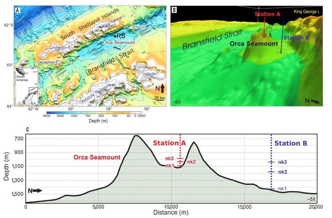
This unusual phenomenon has triggered 85,000 small to large earthquakes since August 2020, originating from Orca Seamount, a dormant volcano that rises 900 meters from the seabed in the Bransfield Strait, a narrow passage between the South Shetland Islands (part of Antarctica) and the northwest tip of the Antarctic continent.

“Fire Monster” Orca Seamount – (Image: REDALYC)
In this region, the Phoenix tectonic plate is subducting beneath the Antarctic continental plate, creating a network of fault zones that lead to complex geological activity.
Scientists at the King George Island research station in the South Shetland Islands were the first to detect the small earthquakes. They quickly connected with colleagues worldwide, comparing data from nearby seismic stations and from satellites orbiting Earth.
According to Science Alert, these pieces of information led to a chain of interconnected earthquakes, with the two strongest recorded in October 2020 at 5.9 on the Richter scale and in November 2020 at 6.0. After that, geological activity gradually weakened. Research also indicates that these tremors have shifted the ground on King George Island by as much as 11 cm.
Only 4% of this movement can be directly attributed to the earthquakes. Growing skepticism about the movement of magma deep underground led researchers to identify the culprit as the “fire monster” Orca Seamount – which has quietly awakened.
However, as of now, there is no direct evidence of an eruption being recorded. Therefore, scientists plan to send a research team directly to the strait to measure the seabed and compare it with previous maps to further substantiate their findings.
This research has recently been published in the scientific journal Communication Earth & Environment.


