According to the National Center for Hydro-Meteorological Forecasting, at 7 AM today (December 17), the center of Typhoon RAI was located at approximately 10.2 degrees North latitude and 121.2 degrees East longitude, over the western sea of Central Philippines. The maximum wind speed near the center of the typhoon was at level 14-15 (150-185 km/h), with gusts exceeding level 17.
Forecast for the next 24 hours: the typhoon is moving rapidly in a west-northwest direction at a speed of 20-25 km/h, gradually weakening.
Thus, by this evening, the typhoon will enter the East Sea. By 7 AM on December 18, the center of the typhoon is expected to be at approximately 11.1 degrees North latitude and 116.2 degrees East longitude, about 200 km east of Song Tu Tay Island. The maximum wind speed near the center of the typhoon will be at level 13-14 (135-165 km/h), with gusts reaching level 17.
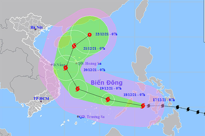
Path of Super Typhoon RAI. (Photo: NCHMF)
Dangerous areas due to the typhoon in the East Sea over the next 24 hours (winds of level 6 or higher, gusts of level 8 or higher): from latitude 8.5 to 14.0 degrees North; east of longitude 113.5 degrees East. All vessels operating in the dangerous area are at high risk of being affected by strong winds, large waves, and tornadoes.
In the next 24 to 48 hours, the typhoon will continue to move in a west-northwest direction at about 20 km/h. By 7 AM on December 19, the center of the typhoon will be located at approximately 12.6 degrees North latitude and 111.9 degrees East longitude, about 280 km east of the coastline of Binh Dinh-Khanh Hoa. The maximum wind speed near the center of the typhoon will be at level 13 (135-150 km/h), with gusts reaching level 16.
Dangerous areas due to the typhoon in the East Sea over the next 24 to 48 hours (winds of level 6 or higher, gusts of level 8 or higher): from latitude 9.0 to 15.0 degrees North; west of longitude 118.0 degrees East. All vessels operating in the dangerous area are at high risk of being affected by strong winds, large waves, and tornadoes.
Due to the impact of the typhoon combined with cold air, the northern area of the East Sea (including the waters of the Paracel Islands) will experience gradually increasing winds of level 7-8, with gusts up to level 10; in the eastern waters of the central East Sea (including the northern waters of the Spratly Islands), winds will strengthen to level 8-10, later increasing to levels 11-12, with winds near the center of the typhoon reaching levels 13-14 and gusts of level 17; waves will be at their highest from 8 to 10 meters; the sea will be extremely rough.
A natural disaster risk warning level for the eastern waters of the central East Sea (including the northern waters of the Spratly Islands): level 4.
In the next 48 to 72 hours, the typhoon will change its movement direction to north-northwest, moving at about 15 km/h. By 7 AM on December 20, the center of the typhoon will be located at approximately 15.6 degrees North latitude and 110.2 degrees East longitude, about 150 km east of the coastline of Da Nang-Binh Dinh. The maximum wind speed near the center of the typhoon will be at level 12 (120-135 km/h), with gusts reaching level 15.
In the next 72 to 96 hours, the typhoon will change its movement direction to northeast, moving at about 15 km/h, with intensity gradually decreasing; in the following 96 to 120 hours, the typhoon will change direction to northeast, moving at 10-15 km/h, with intensity continuing to decrease.
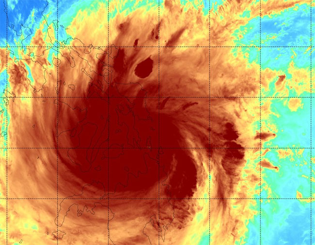
Super Typhoon RAI. (Photo: U.S. Navy)
Previously, the Prime Minister had issued Dispatch No. 1737 to localities regarding urgent responses to Super Typhoon RAI approaching the East Sea.
To proactively respond to the typhoon’s developments, the Prime Minister requested the National Steering Committee for Disaster Prevention and Control, ministries, sectors, and localities to closely monitor the typhoon’s progress, decisively directing and implementing timely response measures to the typhoon.
The People’s Committees of coastal provinces and cities are to coordinate with border guard forces and relevant agencies to review and clearly identify all vessels still operating at sea and activities on the sea. They are to closely monitor the typhoon’s progress, directing information and guidance for vessels to move to safe shelters, firmly ensuring that no vessels operate in areas at risk of being affected by the typhoon.
The dispatch also requires localities to review and prepare plans to proactively respond to situations where the typhoon may affect their areas, ensuring they are not caught off guard…
