According to experts, a once-in-a-thousand-years flood recently occurred in Henan Province (China), affecting over 7.5 million residents, resulting in 56 fatalities and more than 1.5 million people being evacuated. The estimated damage is over $10 billion, which is not expected to impact Vietnam.
Unprecedented Rainfall in Henan Province, China
Regarding the historic flooding in Henan Province, Mr. Mai Van Khiem, Director of the National Center for Hydro-Meteorological Forecasting, told reporters: “Currently, it is the rainy season in China, so the occurrence of heavy rainfall is in line with seasonal patterns. However, the amount of rainfall exceeding 600 mm within 24 hours in Henan is indeed excessive and has been assessed by Chinese meteorological authorities as the heaviest rainfall in the past 1,000 years in Henan Province, China.”

Mr. Mai Van Khiem, Director of the National Center for Hydro-Meteorological Forecasting.
According to Mr. Khiem, there has not yet been a specific study assessing the causes of this extreme heavy rainfall. However, one of the causes of such severe and rare natural disasters is linked to climate change. Climate change leads to alterations in the frequency, intensity, spatial scale, timing, and operational patterns of extreme weather and climate events: Rising temperatures can intensify atmospheric disturbances such as tropical convergence zones, cyclones, storms, tropical depressions, heavy rain, thunderstorms, and tornadoes, making them stronger and more frequent.
Forecasting Heavy Rainfall, Especially Extreme Rain, Remains a Major Challenge
Evaluating the forecasting of heavy rainfall, particularly extreme rainfall forecasts, Mr. Khiem believes that in recent years, with advancements in science and technology, meteorological forecasting worldwide has made certain progress. However, forecasting heavy rainfall remains a significant challenge globally, especially for extreme rainfall.
“We are currently able to forecast areas of heavy rain well, but we cannot accurately predict rainfall amounts at specific locations and times. The current forecasting technology worldwide lacks the capability to predict rainfall reaching several hundred mm within a few hours. High-resolution numerical simulation studies using non-hydrostatic models have indicated that numerical model forecasts have low predictive accuracy, especially for heavy rainfall levels. This is due to the atmospheric predictability being strongly influenced by disturbances that are very small in spatial and temporal scale. A small convective trigger or deviation of the low-level moisture convergence center can lead to very rapid changes in atmospheric instability and create different deep convective distributions resulting in varying rainfall outcomes,” Mr. Khiem shared.
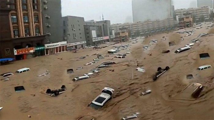
Vehicles swept away in floodwaters in Zhengzhou, Henan Province, Central China. (Photo: Guardian).
According to actual statistics, it is not only in recent years that storms with very unusual paths or the simultaneous occurrence of 2-3 storms or dangerous interacting systems have appeared, but such cases have also occurred in the past, causing significant meteorological disasters that have resulted in considerable loss of life and property.
The reason for the simultaneous occurrence of 2-3, or even 3-4 storms is due to the activity of the tropical convergence zone, which typically forms during the rainy and stormy months (from June to November each year). This tropical convergence zone can stretch for thousands of kilometers. There are always low-pressure centers along the convergence zone, and if conditions are favorable, these low-pressure centers will intensify and form storms or tropical depressions.
Forecasting the simultaneous activity of storms and the interaction of weather systems is very complex and challenging, requiring continuous monitoring to detect small changes in atmospheric circulation. Currently, due to the limited and sparse meteorological observation systems over the South China Sea and in the Pacific region, it is very difficult to forecast storms with complex movement patterns or those influenced by other storms.
Will the Heavy Rainfall in Henan, China, Affect Vietnam?
Mr. Khiem stated that the heavy rains in 2020, which caused record flooding threatening the Three Gorges Dam on the Yangtze River, were due to the Meiyu Front (the main weather system causing rain in China and East Asia) maintaining prolonged activity with above-normal intensity.
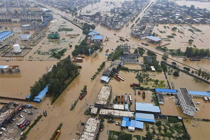
Many villages in Henan Province remain submerged in water (Photo: SCMP).
In 2020, the Meiyu Front (the boundary separating two air masses with different temperatures) persisted, causing rain from mid-April to June. In this year (2021), heavy rain has occurred in the Yellow River system, which is upstream of the Yangtze River system, deep inland in northern China, due to a marine air mass pushing in from the east combined with a low vortex, resulting in heavy rainfall in the Yellow River system, particularly in Zhengzhou, Henan Province, China.
“Henan Province is located in central China, quite far from Vietnam, so the recent historic flooding here will not affect Vietnam,” Mr. Khiem emphasized.
The Vietnam Hydro-Meteorological Agency noted that the ENSO phenomenon is expected to maintain a neutral state until early 2022. The forecast for cold air in 2021 shows many similarities to 2020, although the intensity may not be as strong. Northern Vietnam is expected to have a dry winter this year with many sunny days and cold nights.
Regarding storm forecasts, it is anticipated that storms will be concentrated in October and November 2021, possibly extending into December, but not as intense as in 2020. Storms and heavy rains in central Vietnam, particularly in the Central and Southern Central regions, are expected to occur frequently in October and November, possibly extending into December 2021.
