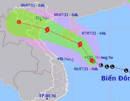
On July 6, a tropical depression strengthened from a low-pressure area over the South China Sea, with a possibility of developing into a storm today.
The National Center for Hydro-Meteorological Forecasting reported that the maximum wind speed at the center of the tropical depression is 49 km/h, equivalent to level 6, with gusts increasing by two levels. It is forecasted that today, the tropical depression will move northwest at a speed of about 10 km/h and may strengthen into a storm. By 4 AM tomorrow, the storm center is expected to be about 120 km southeast of Hainan Island (China), with maximum wind speeds of 74 km/h, equivalent to level 8.
International stations have not yet reported on the tropical depression over the South China Sea.

Path of the tropical depression. (Photo: NCHMF)
Mr. Nguyễn Văn Hưởng, Head of the Climate Forecasting Department (National Center for Hydro-Meteorological Forecasting), stated that at the same time, a tropical depression has also appeared south of Taiwan (China), but it will not affect mainland Vietnam.
“However, the presence of the external tropical depression will prevent the maritime air mass from pushing in, causing the tropical depression over the South China Sea to move northwest today,” Mr. Hưởng said.
As the tropical depression over the South China Sea strengthens into a storm, the tropical depression to the north will make landfall in Fujian Province (China). At this time, the maritime air mass will push in, causing the storm to change direction to west-northwest.
Due to the influence of the storm’s circulation, from tomorrow (July 7) until the end of July 8, the northern region and northern central Vietnam will experience heavy rainfall, with common precipitation exceeding 100 mm, and some areas may exceed 200 mm.
The danger zone for the tropical depression that may strengthen into a storm over the South China Sea in the next 24 hours (winds of level 6 or higher, gusts of level 8 or higher) lies between 14.5 and 19 degrees North; from 110 to 114 degrees East.
The western sea area of the northern South China Sea (including the waters around the Paracel Islands) will experience strong winds of level 6, increasing to level 7, with winds near the storm center reaching level 8, gusting to level 10, and wave heights from 2.5 to 4.5 meters.
If the tropical depression strengthens into a storm, it will be the third storm in the South China Sea this year. Meteorological agencies predict that in 2021, the number of tropical cyclones in the South China Sea affecting Vietnam will be similar to the long-term average (12-14 storms), with 5-6 storms directly impacting the mainland.
In the first half of the season (June to September), tropical cyclones will concentrate in the northern and central South China Sea and may affect northern Vietnam and the northern central region; in the second half of the season (September to November), they will concentrate in the central and southern South China Sea, affecting the northern central region and areas further south.


