NASA Compiles Over 1,100 Images from the Perseverance Rover’s Camera to Create the Most Detailed Panoramic Image of the Red Planet’s Surface.

NASA Shares the Most Detailed Images of Mars’ Surface Ever, Accompanied by Video.
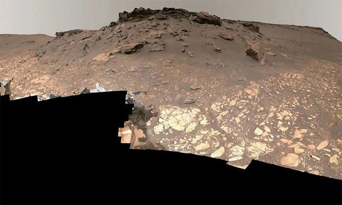
The new panoramic image of Mars showcases rocks, sand, the sky, and part of the rover itself. On September 14, NASA released the most detailed images of Mars’ surface ever, along with a video. In the video, Rachel Kronyak, a member of the Perseverance scientific operations team, guides viewers through an ancient river delta in the Jezero crater. The video also highlights sedimentary rocks, hills, cliffs, the rover’s wheel tracks, and the area designated for sample collection.
The resolution of the new image far exceeds that of the Gale Crater panorama taken by the Curiosity rover in 2020 (1.8 billion pixels). This image was created from 1,118 individual photos captured using the Mastcam-Z camera system of Perseverance, which is located on the rover’s “head,” between June 12 and June 20. The processed color version weighs in at 3.85 GB. NASA shared the video ahead of a press conference summarizing Perseverance’s 1.5 years on Mars.
The delta area depicted in the image is significant for exploration due to its history of containing water. NASA hopes that Perseverance will help answer the question of whether Mars ever had bacterial life. The rover is currently collecting samples in the delta to bring back to Earth for future study.
Video Exploring the Detailed Panoramic Image of Mars’ Surface. (Image: NASA).


