More than 2 million people and 800,000 properties on the East Coast of the United States will be affected.
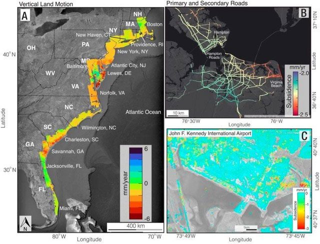
The entire East Coast of the United States is gradually sinking. Urban areas are experiencing subsidence at an increasing rate—up to 5 mm per year. This level of subsidence is sufficient to put the coastline on high alert, according to a new study by a group of American scientists based on satellite data.
Specifically, scientists at Virginia Tech and the United States Geological Survey (USGS) have examined radar satellite data in order to create a digital terrain map showing the landscapes that are sinking.
The research team claims to have produced one of the world’s first high-resolution descriptions of land subsidence, revealing that vast areas of the East Coast of the United States are sinking at least 2 mm per year. In particular, an area of more than 3,700 square kilometers on the East Coast is sinking more than 5 mm per year.
From New York City (New York), Baltimore (Maryland), to Norfolk (Virginia), these regions are quietly sinking at a rate of 1 to 2 mm per year.

Satellite imagery shows the East Coast of the United States facing severe subsidence. (Source: Leonard Ohenhen).
Scientists warn that if this trend continues, it could lead to severe damage to infrastructure and harm the residents and properties in these areas.
This subsidence poses serious threats, including eroding the foundations of buildings, damaging roads, gas/water pipelines, causing building collapses, and worsening coastal flooding alongside rising sea levels due to climate change.
Subsidence of 2 mm: 2 million people and 800,000 properties affected
Leonard Ohenhen, who works at the Innovation and Earth Observation Laboratory at Virginia Tech and is the lead author of the study, stated: “The issue is not only that the ground is sinking, but that hotspots of land subsidence directly intersect with major population centers and infrastructure.“
Co-author of the study and Professor of Geophysics at Virginia Tech, Manoochehr Shirzaei, added: “When you combine the subsidence with the global sea level rise of over 4 mm per year, things start to get worse. We have measured a subsidence rate of 2 mm per year, affecting more than 2 million people and 800,000 properties on the East Coast of the United States. This is not an invisible threat. Every millimeter of sinking is alarming.”
“This indicates that the more catastrophic consequences of subsidence on the East Coast of the United States can be mitigated by proactive policies—such as climate change mitigation policies,” the scientists wrote in the study.
This finding was recently published in the Proceedings of the National Academy of Sciences of the United States.


