The temperature recorded at Mount Son at 6 AM this morning was -2.2 degrees Celsius, in Sa Pa it was 3.8 degrees, and in Hanoi, it was 12 degrees; tonight’s weather forecast indicates the lowest temperatures of this cold wave. This cold spell is expected to last until December 25.
According to the National Center for Hydro-Meteorological Forecasting, this morning (December 22), due to the influence of a strengthened cold front, many areas in the North experienced significant temperature drops, notably Mount Son (Lang Son) at only -2.2 degrees (at 6 AM), while in Sa Pa (Lao Cai) it was 3.8 degrees, Cao Bang 6.5 degrees, Bai Chay (Quang Ninh) 8.9 degrees, and Hanoi at 12 degrees, among others. By around 7-8 AM, temperatures in these areas rose by approximately 0.5-1 degree.
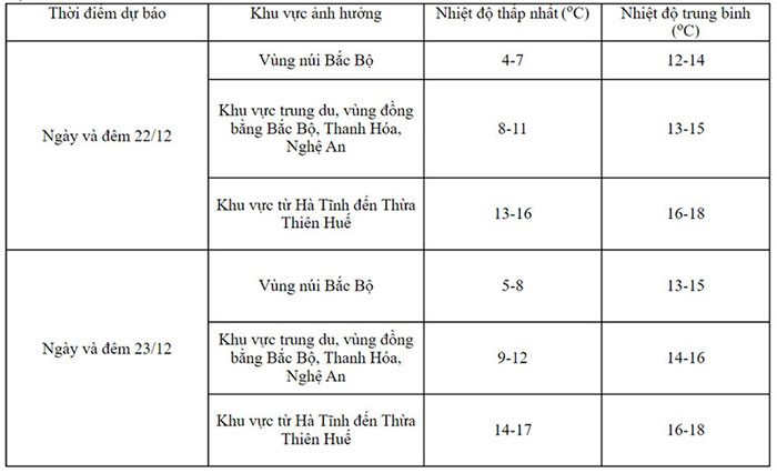
The weather forecast for today indicates that severe cold and frost will continue in the North, with cold air extending down to Thua Thien Hue. Tonight, temperatures are likely to drop to the lowest levels observed during this cold spell.
This morning, the dry cold weather was palpable, with many people on the streets feeling the biting chill.

Detailed temperature forecast for regions on December 22-23. (Photo: NCHMF).
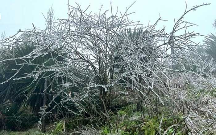
The meteorological agency warns that this widespread cold and frost in the Northern region and the provinces of Thanh Hoa and Nghe An may persist until around December 25. During this cold spell, frost and ice are likely to occur in the midland and mountainous areas of the North.
Additionally, from Ha Tinh to Khanh Hoa, rain, including moderate to heavy rain, is expected today, with rainfall amounts ranging from 15-30mm, and in some places exceeding 50mm. Notably, from December 23-24, there is a potential for moderate to heavy rain, and in some areas, very heavy rain and thunderstorms are forecasted from Da Nang to Binh Thuan.
Localized heavy rain may cause flash floods on small rivers and streams, landslides on slopes, and flooding in low-lying areas.

This morning, the temperature in Mount Son (Lang Son) dropped to -2.2 degrees Celsius. (Illustrative photo)
Furthermore, according to the Southern Regional Hydro-Meteorological Station, in addition to the strengthening cold air on December 22, another wave is expected to arrive around December 27.
Looking further ahead, the National Center for Hydro-Meteorological Forecasting predicts that from now until the end of December, the cold air will continue to be active, and severe cold and frost may appear in the Northern and North Central regions.
In January 2024, the cold air is expected to be less active than the multi-year average (MYA), with fewer days of severe cold and frost compared to the MYA.
Over the next month, the average temperature across the country is likely to remain higher than the MYA by 0.5-1 degree, while the Northwest region of the North might be higher by 1-2 degrees compared to the MYA during the same period.
Regarding rainfall trends in Central Vietnam, the meteorological agency indicated that moderate to heavy rain events are likely to occur, particularly in the Central and Southern Central regions in the final days of December, with a trend of decrease expected in early January 2024.
The total rainfall in this region is forecasted to exceed the MYA by 30-60mm, while other regions are expected to be around the MYA, with deficits of 5-10mm compared to the MYA during the same period.
In the last days of December and into January 2024, the likelihood of storms/tropical depressions in the East Sea is low.


