Experts explain why, despite winter starting nearly a month ago, the highest temperatures in northern Vietnam have reached 30 degrees Celsius on some days, creating a summer-like heat sensation.
The winter of 2023-2024 has been underway for 20 days, with strong cold air waves sweeping into the country, causing a significant drop in temperatures in the northern region, leading to chilly weather, and even severe cold in mountainous areas.
However, at this point, even though it is late November, the highest temperatures in northern Vietnam are still notably high, with some days hitting around 30 degrees Celsius. The intense sunshine and low humidity contribute to a dry and uncomfortable atmosphere, making residents feel as if it were summer.

Currently, the weather feels summery at times.
Warm Temperatures Close to 30 Degrees Celsius in Winter
In response to VTC News regarding this issue, Ms. Lê Thị Xuân Lan, former Deputy Head of the Southern Regional Meteorological Center, stated that the weather is currently at the end of November, approaching the main winter phase.
Typically, in November, the cold air is not too strong and not continuous. When the cold air weakens, temperatures rise, which is a normal occurrence.
“When the temperature in the meteorological shelter reaches 29-30 degrees Celsius, the temperature felt by people outdoors is about 3-4 degrees Celsius higher, meaning it exceeds 30 degrees Celsius. This winter is particularly notable as the weakening cold air leads to a clear increase in temperatures, which is unusual,” Ms. Lan explained.
Explaining this abnormal phenomenon, the former Deputy Head of the Southern Regional Meteorological Center attributes it to climate change.
Additionally, El Niño is currently at its peak phase. This phenomenon is expected to last until around March or April 2024, throughout the main winter period.
Mr. Nguyễn Hồng Sinh, Deputy Director of the Hải Phòng Meteorological Center, noted that the first cold air wave of the season affecting Vietnam does not occur frequently, about once every 7-10 days. During the early season, warm sunny periods will alternate with cold air waves.
“The main reason for the recent dry and sunny days is that Hải Phòng is deeply embedded in a cold and dry air mass, leading to dry conditions combined with divergent upper-level airflow, resulting in clear skies and no rain. It is cold at night, sunny during the day, with a high temperature variation between day and night,” Mr. Sinh analyzed.
He also mentioned that currently, the weather is still influenced by a slowly weakening continental cold air mass. From November 30 to December 2, this cold air mass is expected to be reinforced again, with stable intensity afterward.
During this cold wave, temperatures in Hải Phòng are not expected to drop significantly, with nighttime lows around 16-18 degrees Celsius and daytime highs around 24-26 degrees Celsius. Following this, as the cold air weakens, temperatures will gradually rise again.
Late Arrival of Severe Cold Forecasted This Year
Ms. Lê Thị Xuân Lan believes that this winter will not be as cold as those during La Niña years, but there may still be strong cold air waves and frost in higher mountainous areas above 1,500-2,000 meters.
Snow may occur but is unlikely and limited to a narrow area, and it is expected that this winter’s weather pattern will resemble the main winter of 1997-1998, during a strong El Niño event.
“In La Niña years, during the main winter, cold air is almost continuous, with new waves arriving before the previous ones weaken. However, this year will see interruptions between cold air waves. Therefore, from December onwards, the hot weather pattern will significantly decrease, but we cannot rule out the possibility of this weather returning for 1-2 days,” she shared.
“Typically, in December, there are about 6 cold air waves; this year, there may only be about 4, with warm days likely in between,” Ms. Lan added.

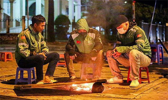
This winter, cold air activity is expected to be weaker than the long-term average. (Photo: Ngô Nhung)
The former Deputy Head of the Southern Regional Meteorological Center also warned of extreme weather that could occur during warmer spells between cold air waves, advising residents to be cautious of unusual heavy rain in mountainous regions, thunderstorms, and strong winds. Especially in winter, many people choose highland areas as travel destinations.
According to the Deputy Director of the Hải Phòng Meteorological Center, the current atmospheric and oceanic conditions are influenced by El Niño. It is forecasted that in the coming months, El Niño will continue to persist with a probability of over 95%.
This winter of 2023-2024, cold air activity is expected to be weaker than the long-term average. Severe cold and frost may appear late, and the number of days with severe cold and frost is trending lower than the long-term average for this period. However, we still need to be cautious of strong cold air waves, especially during the main winter months,” Mr. Sinh informed.

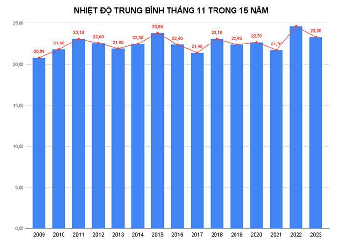
Average temperature in November over the past 15 years (recorded in Hải Phòng).

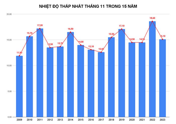
Lowest temperature in November over the past 15 years (recorded in Hải Phòng).
According to Mr. Sinh’s observations, cold air will continue to affect the northern provinces in the early winter months, with a stronger impact expected during the main winter months. Approximately 24-26 cold air waves are expected to affect Hải Phòng during this winter, which is fewer than the long-term average.
“Severe cold and frost are expected to occur from late December 2023 to February 2024, with about 4-6 waves. The first wave of severe cold and frost in Hải Phòng is likely to occur in late December 2023, later than the long-term average. The lowest temperature during the winter of 2023-2024 is expected to be around 7-9 degrees Celsius,” Mr. Sinh stated.
Statistics from the past 15 years in Hải Phòng show that in November 2023, the average temperature reached 23.3 degrees Celsius (as of November 26), which is higher than in several previous years by 0.2-2.5 degrees Celsius. However, some years recorded lower averages, such as 2015 at 0.5 degrees Celsius lower and 2022 at 1.3 degrees Celsius lower.
The lowest temperature was recorded at 15.1 degrees Celsius on November 17. This temperature is lower than in several years, such as 2010, 2011, 2014, 2018, 2019, and 2022. In 2022, the lowest temperature in November was 18.6 degrees Celsius.
“Data from the past 15 years indicates that November 2023 is not the year with the highest temperatures. Specifically, in November 2022, the average temperature reached 24.6 degrees Celsius, while in November 2023 it was 23.3 degrees Celsius (as of November 26). The lowest temperature in November 2022 was 18.6 degrees Celsius, while in November 2023 it was 15.1 degrees Celsius (as of November 26),” Mr. Sinh reported.
|
El Niño (Spanish for “the child of God”) refers to the abnormal warming of the surface waters in the central and eastern Pacific equatorial region, lasting 8-12 months or longer, typically occurring 3-4 times, but sometimes more or less frequently. On the other hand, La Niña (also known as “the girl child”) is the phenomenon opposite to El Niño, characterized by an abnormal cooling of the surface waters in the aforementioned region, occurring with a similar or less frequent cycle than El Niño. |


