The European Space Agency announced on March 18 the release of images of Lake Nasser, one of the largest artificial lakes in the world, captured by the Copernicus Sentinel-2 satellite.
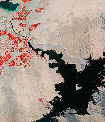
Lake Nasser is located in southern Egypt and northern Sudan, formed by the construction of the Aswan Dam on the Nile River in the late 1960s. This ambitious project was implemented to provide irrigation water for agriculture and attract people to the region. In the image, the lake is visible in the lower right corner and appears black in color.

A section of Lake Nasser as captured by the Copernicus Sentinel-2 satellite. (Photo: ESA)
The Aswan Dam is located about 200 km northeast of the area shown in the image. The dam stores floodwaters from the Nile River and releases them when needed, providing water for hundreds of thousands of hectares of land downstream as well as surrounding areas. The dam also improves transportation through Aswan and generates a significant amount of hydroelectric power. The lake has a total surface area of 5,250 km² and an average depth of 25 meters.
The Abu Simbel temple complex of ancient Egypt was once submerged due to the rising waters of the Aswan Dam, necessitating its relocation. In the 1960s, this historic site was dismantled piece by piece and reassembled at a new location to avoid flooding. In the image, the town of Abu Simbel and its airport are located at the very bottom, near several plantations marked in red.
A portion of Toshka Lake, a natural depression filled by overflow from Lake Nasser, appears in the upper left corner of the image. This lake was formed in the 1980s and 1990s due to the diversion of water from Lake Nasser through the artificial canal depicted in the image.
The water levels of the lakes depend on the flow from the Nile River. Between 2012 and 2018, the lakes shrank significantly. However, summer rainfall in Sudan in 2019 and record floods in 2020 caused the lake levels to rise rapidly. The lakes are relatively saline, showing signs of eutrophication, and algae are also visible in the image.
The images released by the European Space Agency (ESA) are processed color composites created using the near-infrared channel of the Copernicus Sentinel-2 to highlight the sparse vegetation in the region. This helps to identify the circular fields in the image, with the largest field having a diameter of approximately 750 meters.


