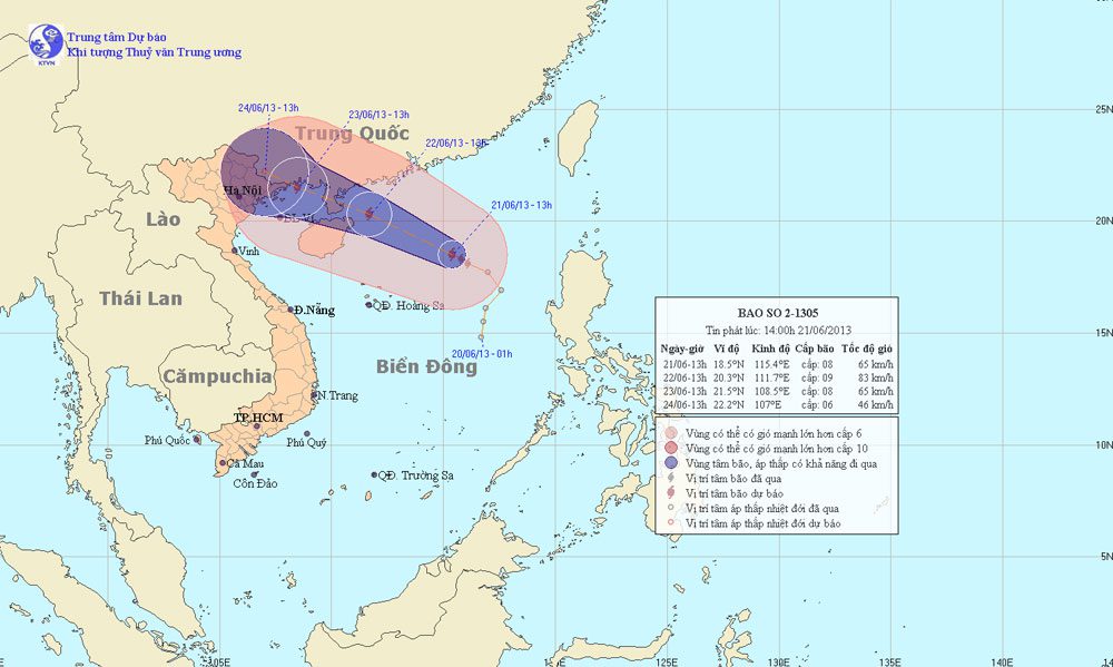
According to the Central Meteorological and Hydrological Forecasting Center, early this morning (June 21), the tropical depression has intensified into a storm. This is the second storm to occur in the South China Sea and is internationally named Bebinca.
As of 1 PM, the storm’s center was located at approximately 18.5 degrees North latitude and 115.4 degrees East longitude, about 400 km northeast of the Paracel Islands. The strongest winds near the storm’s center are at level 8 (ranging from 62 to 74 km/h), with gusts reaching levels 9 and 10.
It is forecasted that in the next 24 hours, the storm will move in a north-northwest to northwest direction at a speed of about 15 to 20 km/h. By 1 PM on June 22, the storm’s center will be located at approximately 20.3 degrees North latitude and 111.7 degrees East longitude, about 440 km southeast of Mong Cai (Quang Ninh). The strongest winds near the storm’s center will be at level 9 (ranging from 75 to 88 km/h), with gusts reaching levels 10 and 11.
In the next 24 to 48 hours, the storm is likely to change its direction to west-northwest, moving at about 15 km/h. By 1 PM on June 23, the storm’s center will be located at approximately 21.5 degrees North latitude and 108.5 degrees East longitude, over the Mong Cai area (Quang Ninh). The strongest winds near the storm’s center will be at level 8 (ranging from 62 to 74 km/h), with gusts reaching levels 9 and 10.
In the next 48 to 72 hours, the storm will continue to move in a west-northwest direction at a speed of about 5 to 10 km/h.
Due to the storm’s influence, the northern areas of the North China Sea will experience strong winds at levels 6 and 7, with winds near the storm’s center reaching levels 8 and 9, and gusts up to levels 10 and 11. The sea will be very rough. Starting from the afternoon of June 22, the waters of the Gulf of Tonkin will see winds gradually increasing to levels 6 and 7, with winds near the storm’s center at levels 8 and 9, and gusts up to levels 10 and 11. The sea will be very rough. Coastal areas in the northeastern provinces will experience gradually increasing winds at levels 6 and 7 from the morning of June 23, with winds near the storm’s center at level 8. In northern and central northern provinces, rain and moderate rain are expected from the night of June 22; particularly, the northeastern region and northern mountainous provinces may experience heavy to very heavy rainfall.
Additionally, due to the influence of a strong southwest wind, the Paracel Islands, the waters from Binh Thuan to Ca Mau, and the central and southern parts of the South China Sea (including the Spratly Islands) will experience strong southwest winds at level 5, occasionally reaching level 6, with gusts up to levels 7 and 8, along with heavy showers and thunderstorms. The sea will be rough. In thunderstorms, it is essential to be cautious of tornadoes.


