Typhoon Noru is expected to reach maximum wind speeds of levels 13-14, with gusts up to level 17 in the South China Sea. From the afternoon of September 27, many areas in Central Vietnam and northern Central Highlands will begin to feel the effects of this system.
The National Center for Meteorological and Hydrological Forecasting reported that in the early hours of September 26, Typhoon Noru passed over the southern region of Luzon Island (Philippines) and entered the South China Sea. This is the fourth typhoon of the year to occur in this area.
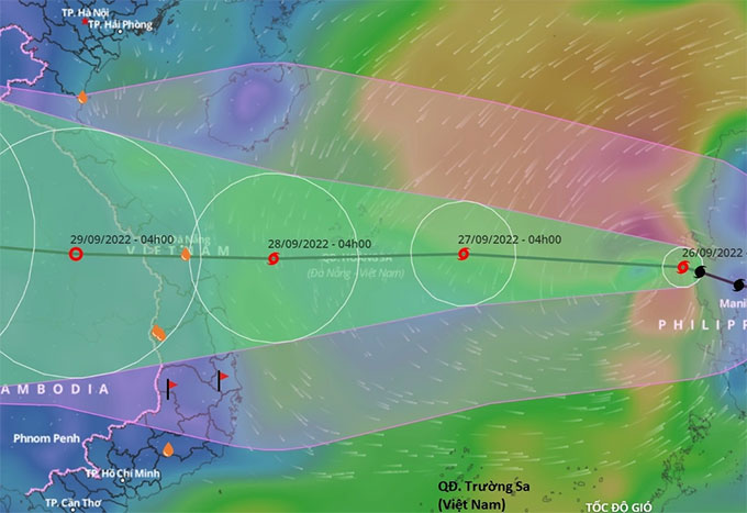
Forecast path of Typhoon No. 4 (Noru) in the South China Sea. (Photo: VNDMS).
At 4 AM, the center of the typhoon was located over the waters west of Luzon Island, approximately 810 km east of the Paracel Islands. The maximum wind speed was recorded at levels 12-13, with gusts reaching level 14. The typhoon weakened by 2 levels after moving over land.
Today and tonight, the typhoon is expected to move mainly in a west-northwest direction at a speed of 20-25 km/h. By early morning on September 27, the center of the typhoon will be about 250 km southeast of the Paracel Islands. The maximum wind speed is expected to be level 13, with gusts up to level 16.
After this point, the typhoon will maintain its speed while moving directly west and is likely to strengthen. By early morning on September 28, the center of the typhoon will be about 170 km east of the coastline of Da Nang – Binh Dinh. The maximum wind speed will reach levels 13-14, with gusts up to level 17. This will be the peak intensity of the typhoon.
With constant speed and direction, the typhoon is forecasted to make landfall in Central Vietnam on September 28, before gradually weakening into a tropical depression. By early morning on September 29, the center of the tropical depression will be located over southern Laos.
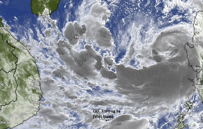
Satellite image of Typhoon Noru in the South China Sea on September 26. (Photo: Windy).
Similarly, the Japan Meteorological Agency predicts that by the evening of September 27, as the typhoon approaches the coastal waters of Central Vietnam, the maximum wind speed will reach 162 km/h, equivalent to level 14, with gusts up to level 17.
However, this agency indicates that the area affected by the typhoon is narrower and shifted north compared to previous forecasts, stretching from Quang Binh to Quang Ngai.
In a more extreme scenario, the Hong Kong Observatory suggests that the typhoon could reach maximum wind speeds of 175 km/h, equivalent to level 15, with gusts up to level 17 as it approaches the shore. After passing through Quang Binh – Quang Ngai, this system could still maintain strong winds of level 9 over southern Laos.
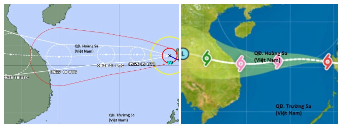
The Japan Meteorological Agency and Hong Kong Observatory have provided two different forecasts regarding the intensity of Typhoon Noru as it approaches the central coast on September 27. (Photo: JMA and HKO).
The meteorological agency warns that the southern waters of the northern South China Sea (including the waters of the Paracel Islands) and the central South China Sea will experience stormy weather, with strong winds of levels 8-9, increasing to levels 10-11. The area near the typhoon’s center will see winds of levels 12-14, gusts up to level 17, and waves reaching heights of 8-10 meters; the sea will be extremely turbulent.
From noon on September 27, the offshore waters from Quang Binh to Ninh Thuan (including Con Co Island, Cu Lao Cham, and Ly Son) will experience strong winds of levels 8-9, increasing to levels 10-11. The area near the typhoon’s center will have winds of levels 12-14, with gusts up to level 17, and waves reaching heights of 8-10 meters.
From the evening and night of September 27, the coastal waters from Thua Thien – Hue to Binh Dinh will have wave heights of 3-5 meters, and near the typhoon’s center, waves could reach 6-8 meters.
Experts warn that areas from Quang Tri to Quang Ngai should be prepared for storm surge of 1-1.5 meters, which may cause flooding in low-lying coastal areas and river mouths.
All ships, aquaculture areas, and activities in these waters are at high risk of being affected by strong winds, large waves, tornadoes, and storm surges.
On land, by early morning on September 28, the coastal areas from Quang Tri to Ninh Thuan are expected to experience strong winds of level 6, increasing to levels 7-8, with gusts up to levels 9-10.
At the same time, coastal areas in Da Nang, Quang Nam, Quang Ngai, and Binh Dinh will see strong winds of levels 9-10, with areas near the typhoon’s center experiencing winds of levels 11-12, gusts up to levels 14-15. Areas further inland will have winds of levels 8-9, with gusts up to levels 12-13.
Specifically, the areas of Kon Tum and Gia Lai will experience gradually increasing winds of level 6, increasing to levels 7-8, with some areas reaching level 9, and gusts up to level 11.
It is noteworthy that from the afternoon of September 27 to September 28, the Central Vietnam and northern Central Highlands regions will experience heavy rainfall, with common rainfall amounts of 150-300 mm, and some areas exceeding 350 mm. From September 28-30, rainfall is expected to extend to the northern Central Vietnam region.


