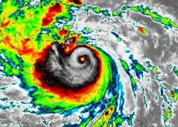
Typhoon SAOLA currently has maximum wind speeds near the center ranging from 15 to 16 (167-201 km/h), with gusts exceeding level 17 (super typhoon level). It is moving towards the East Sea at a speed of 10-15 km/h.
According to the National Center for Hydro-Meteorological Forecasting, as of 7 AM on August 30, the center of Typhoon SAOLA is located at approximately 20.2 degrees North latitude and 121.1 degrees East longitude, over the northern waters of Luzon Island (Philippines). The maximum wind speed near the center of the typhoon is level 15-16 (167-201 km/h), with gusts exceeding level 17 (super typhoon level), moving in a northwest direction at a speed of 10-15 km/h.
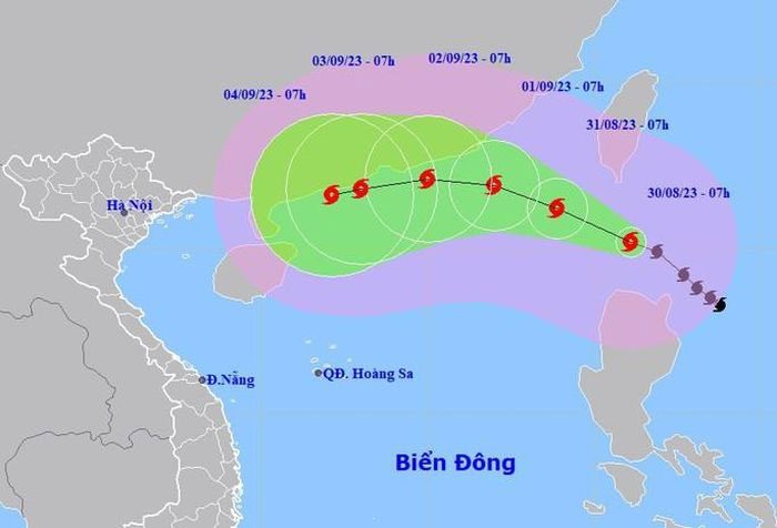
Forecast position and direction of Typhoon SAOLA. (Source: National Center for Hydro-Meteorological Forecasting).
By 7 AM on August 31, the center of Typhoon SAOLA is at 21.2 degrees North latitude and 118.9 degrees East longitude, moving northwest at a speed of about 10-15 km/h, with a strength of level 15 and gusts over level 17 as it enters the East Sea. The dangerous area affected by the typhoon is north of latitude 17.5 degrees North, east of longitude 118 degrees East; the northeastern region of the northern East Sea has a disaster risk level of 3.
By 7 AM on September 1, the center of Typhoon SAOLA is at 21.9 degrees North latitude and 117 degrees East longitude, moving west-northwest at about 10 km/h, entering the East Sea with a strength of level 14 and gusts of level 17. The dangerous area affected by the typhoon is north of latitude 18 degrees North, east of longitude 114.5 degrees East; the northeastern region of the northern East Sea has a disaster risk level of 3.
By 7 AM on September 2, the center of Typhoon SAOLA is at 22.1 degrees North latitude and 115 degrees East longitude, moving west at about 10 km/h, with a strength of level 13 and gusts of level 16. The dangerous area affected by the typhoon is north of latitude 18.5 degrees North, east of longitude 111.5 degrees East; the northern region of the northern East Sea has a disaster risk level of 3.
From 72 to 120 hours ahead, Typhoon SAOLA is expected to move primarily in a west-southwest direction at a speed of about 10 km/h, with the intensity likely to weaken gradually.
Due to the impact of Typhoon SAOLA, the northeastern waters of the northern East Sea will experience strong winds of level 6, increasing to levels 7-8 by the afternoon and night of August 30, with winds near the typhoon’s center reaching levels 10-12, later increasing to levels 13-15, with gusts exceeding level 17; the sea will be extremely rough.
|
On the day and night of August 30, the area from Quang Binh to Quang Ngai, the Central Highlands, and the South will experience showers and scattered thunderstorms, with localized heavy rainfall of 20-40mm, and some places exceeding 80mm (with concentrated rain expected in the late afternoon and evening). Localized thunderstorms and heavy rain in the Central Central region may last until around August 31. The Central Highlands and Southern regions may also experience prolonged rain in the coming days. Localized heavy rain may cause flooding in low-lying areas and pose a risk of flash floods and landslides in mountainous regions. The disaster risk level due to storms and lightning is level 1. |
