Today, Typhoon Nalgae is expected to turn northward, instead of continuing westward as it has for the past day, with the potential to strengthen to level 11 (117 km/h).
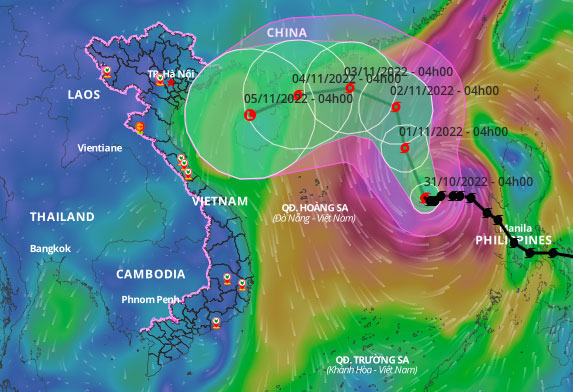
The National Center for Meteorological and Hydrological Forecasting reported that at 4 AM today, the eye of the typhoon was approximately 590 km east of the Paracel Islands, with maximum winds of 102 km/h, classified as level 10, with gusts increasing by two levels.
Forecasts indicate that today the typhoon will move in a north-northwest direction at a speed of 10 km/h. By 4 AM tomorrow, it is expected to be about 530 km northeast of the Paracel Islands, with maximum winds of levels 10-11. After that, the typhoon will continue moving north at a speed of 5-10 km/h, maintaining wind speeds of levels 10-11.

Projected path of the typhoon, 4 AM on October 31. (Photo: General Department of Disaster Prevention and Control)
The Japan Meteorological Agency predicts that today the typhoon will reach its peak, with maximum winds of about 110 km/h, moving north before turning west towards the area between Leizhou Peninsula and Hainan Island (China). The Hong Kong Observatory has similar predictions regarding wind speed and anticipates that the typhoon will weaken into a tropical depression after making landfall on Hainan Island.
The eastern sea area of the northern and central South China Sea is expected to experience strong winds of levels 7-8, increasing to levels 10-11, with gusts reaching level 13. The western sea area of the northern and central South China Sea (including the waters of the Paracel Islands) will see winds of levels 6-7, with gusts of levels 8-9. Wave heights are forecasted to reach 6-8 meters, with areas near the typhoon’s center experiencing waves of 9-11 meters.
Yesterday, the National Steering Committee for Disaster Prevention and Control issued a directive to provinces from Quang Ninh to Binh Thuan, urging them to closely monitor the typhoon’s developments, organize the counting of vessels in at-risk areas, and be ready to mobilize forces if necessary.
Currently, border guards in the provinces have informed and guided over 30,460 vessels with 161,560 crew members about the typhoon’s developments to ensure safe navigation, including 52 vessels with 468 people operating in the dangerous waters of the northern South China Sea and the Paracel Islands.
Since the beginning of this year, the South China Sea has seen 6 typhoons and 2 tropical depressions. Long-term forecasts suggest that from now until January 2023, the South China Sea may experience about 3-5 typhoons and tropical depressions, with 2-3 of them potentially impacting Vietnam directly, particularly in the Central and Southern regions.


