Forecast: As of 7 AM on November 11, the center of Typhoon Toraji is located over the eastern waters of Luzon Island (Philippines). The maximum wind speed near the center of the typhoon is classified at level 12 (118-133 km/h), with gusts reaching level 15. The typhoon is moving in a west-northwest direction at a speed of approximately 20 km/h.
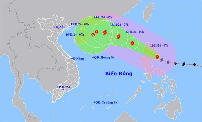
Position and movement direction of Typhoon Toraji. (Source: nchmf.gov.vn).
According to the National Center for Hydro-Meteorological Forecasting, by 7 AM on November 12, the center of Typhoon Toraji will be located at approximately 18.6 degrees North; 118.3 degrees East, over the eastern waters of the northern South China Sea. The maximum wind speed near the center of the typhoon will be classified at level 10, with gusts reaching level 12. The typhoon will continue to move in a west-northwest direction at a speed of about 20 km/h, entering the South China Sea.
By 7 AM on November 13, the center of the typhoon will be at approximately 19.7 degrees North; 116.0 degrees East, over the eastern waters of the northern South China Sea. The maximum wind speed near the center will be level 10, with gusts reaching level 12. The typhoon will move in a west-northwest direction at a speed of about 10-15 km/h.
By 7 AM on November 14, the center of the typhoon will be located at about 20.4 degrees North; 113.7 degrees East, north of the northern South China Sea. The maximum wind speed near the center will be level 8, with gusts reaching level 10. The typhoon will continue moving in a west-northwest direction at a speed of about 10-15 km/h.
From 72 to 120 hours afterwards, the typhoon will continue to move in a west-northwest direction, and may later change direction to west-southwest, traveling at a speed of 5-10 km/h, with intensity continuing to weaken.
Due to the impact of Typhoon Toraji, the eastern waters of the northern South China Sea will experience increasing winds, gradually reaching levels 6-7, then rising to level 8, with areas near the typhoon center experiencing levels 9-10, gusts reaching level 12, and waves rising to 3-5 meters; near the center of the typhoon, waves may reach 5-7 meters; the sea will be very rough.
Warnings state that vessels operating in the aforementioned dangerous areas are at risk of being affected by thunderstorms, whirlwinds, strong winds, and high waves.
