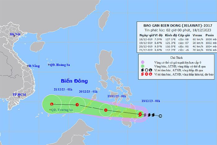
Tropical Storm Jelawat is currently located over the southeastern waters of the southern Philippines, with wind gusts reaching level 10, moving westward at about 20 km/h; it is expected to weaken into a tropical depression before entering the South China Sea.
According to the National Center for Meteorological and Hydrological Forecasting, as of around 1 AM today (December 18), the storm’s center was positioned at approximately 7.9 degrees North latitude and 127.1 degrees East longitude, over the southeastern waters of the southern Philippines.
The maximum wind speed near the storm’s center is at level 8 (62-74 km/h), with gusts reaching level 10, moving westward at about 20 km/h.

Storm Path. (Source: NCHMF)
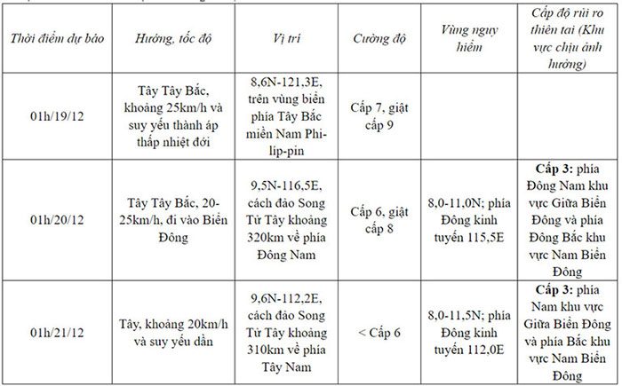
Forecasts indicate that within the next 24 hours, the storm’s center will move over the northwestern waters of the southern Philippines. By 1 AM on December 19, the storm will shift towards the west-northwest at approximately 25 km/h and weaken into a tropical depression, with a strength of level 7 and gusts at level 9.
In the following 24 to 48 hours, the tropical depression is expected to enter the South China Sea, with a possibility of further weakening.
Storm Development Forecast (24 to 72 hours ahead):

(Source: NCHMF)
Meteorological authorities assess that with the continuous influx of cold air, this storm/tropical depression has very little chance of reaching the mainland of our country.
Due to the influence of the storm/tropical depression, the southeastern waters of the central South China Sea and the northeastern regions of the southern South China Sea will experience gradually increasing winds, reaching level 6, with gusts at level 8; the sea will be rough, with wave heights of 2-4 meters.
Additionally, due to the impact of cold air, from now until December 19, the northern South China Sea (including the waters around the Paracel Islands) will see strong northeast winds at level 6, occasionally reaching level 7, with gusts of level 8-9, and wave heights of 4-6 meters, causing strong sea disturbances.
The waters from Ninh Thuan to Ca Mau and the northern areas of the central South China Sea will experience strong northeast winds at level 6, with gusts at level 7-8, and wave heights of 3-5 meters, resulting in rough seas.
On December 19, the Gulf of Tonkin and the waters from Quang Tri to Quang Ngai will have strong northeast winds at level 6, with gusts at level 7-8, and wave heights of 2-4.5 meters, leading to rough sea conditions.


