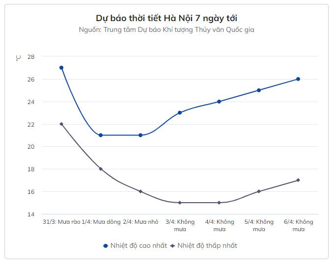
As a strong cold front approaches, Hanoi will experience a drop in temperature starting the night of March 31, with temperatures falling to between 14-17 degrees Celsius. Meanwhile, mountainous areas may record temperatures below 12 degrees Celsius.
The National Center for Hydro-Meteorological Forecasting reports that a cold air mass has formed and is moving towards our country. On the night of March 31, this weather pattern will affect the Northeast region, followed by impacts on other areas in the Northwest, North Central, and Central regions.
From the evening and night of March 31, the northern region will see rain showers and thunderstorms, with localized heavy rainfall. Residents are advised to be cautious of the risks of tornadoes, lightning, hail, and strong winds. This rainy period will last until the end of April 1.
At the same time, the Northern Delta will experience cold weather starting tonight, with common low temperatures ranging from 14-17 degrees Celsius, while mountainous areas may have severe cold conditions below 12 degrees Celsius.
According to Accuweather, Hanoi may record a low of 13 degrees Celsius on the night of April 1. During the day, temperatures will rise to between 18-20 degrees Celsius, remaining chilly. The area will also experience continuous rain and thunderstorms from March 31 to April 1, followed by sunny weather.
In the Central region, provinces from Thanh Hoa to Thua Thien – Hue will experience cold weather on April 1, with minimum temperatures between 15-18 degrees Celsius.
From the night of March 31 to April 2, rain and thunderstorms will increase in the areas of Ha Tinh and Quang Binh, with rainfall ranging from 100-250 mm. Meanwhile, provinces and cities from Quang Tri to Quang Ngai will continue to see heavy rainfall until the end of the week, with totals of 200-350 mm, and some areas may exceed 400 mm per event.
The areas of Binh Dinh, Phu Yen, Khanh Hoa, and the Central Highlands will see rain end earlier on April 1, with rainfall amounts decreasing to between 100-200 mm per event. At the same time, Binh Thuan and Ninh Thuan will experience rainfall of 50-100 mm over the next two days.
The meteorological agency warns that from the night of March 31, winds will shift to the northeast at level 3 inland, and level 4-5 along the coast. In the Gulf of Tonkin, winds will be strong at levels 6-7, with gusts reaching levels 8-9. Waves will be 2-4 meters high.
From April 1, the northern East Sea and offshore areas from Quang Tri to Ca Mau will experience increasing winds up to level 7, with gusts of level 8-9. Waves will be 4-6 meters high, with strong sea conditions.
In light of the worsening weather conditions in the coming days, the National Steering Committee for Disaster Prevention and Control has issued a document requesting local authorities to guide timely measures for the government and residents to proactively prevent flash floods and landslides that may occur in mountainous areas.
At the same time, localities should prepare plans to prevent flooding, especially in urban areas and concentrated residential areas. Relevant authorities in coastal provinces and cities should monitor warnings about strong winds and large waves to provide timely information to captains and owners of vessels operating in the area.
