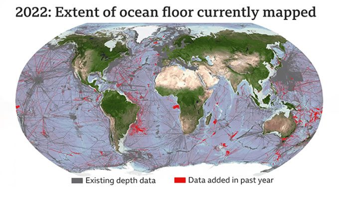
The Seabed 2030 project collects data from governments, companies, and research institutes, aiming to map 100% of the ocean floor by 2030.

Approximately 23.4% of the Earth’s seabed has been mapped thanks to the international Seabed 2030 project, according to the United Nations Ocean Conference held in Lisbon, Portugal from June 27 to July 1. The project heavily relies on voluntary contributions of ocean floor topography data from governments, companies, and research institutes, and is part of a larger initiative called The Ocean Decade by the United Nations.
Seabed 2030 aims to map 100% of the ocean floor by 2030. Researchers believe this goal is feasible due to advancements in technology and the availability of data. In just the past year, Seabed 2030 has added survey data covering approximately 9.8 million square kilometers (equivalent to the size of Europe), primarily through newly public data repositories rather than new mapping efforts.
Scientists believe that collecting more data on the ocean floor topography will help humanity better understand climate change and ocean conservation efforts. Ocean floor maps also aid in detecting tsunamis and other natural disasters.
“A complete map of the ocean floor is the missing tool. It will allow us to address some of the most urgent environmental challenges of our time, including climate change and marine pollution, helping us protect the future of our planet,” said Mitsuyuki Unno, Executive Director of The Nippon Foundation in Japan.
Most of the data used for Seabed 2030 is already available. The project team relies heavily on contributions from governments and companies, but some remain hesitant to fully disclose their data repositories for fear of revealing national or commercial secrets.
“They really don’t need to worry. One of the messages we are trying to convey is that we are not asking for high-resolution data. High resolution is great; we can work with that. But lower resolution is also perfectly acceptable. The depth value in an area the size of a European football field, 100 m x 100 m or equivalent, will not expose national or commercial secrets,” said Jamie McMichael-Phillips, Director of Seabed 2030.
All the data that Seabed 2030 is collecting will be made publicly available online through the global GEBCO network. Before Seabed 2030, very little direct ocean floor survey data was made available for public use. Most ocean floor topography measurements were estimated using satellite altimetry data, providing only a preliminary visualization of the seabed’s shape.
Some scientists believe that efforts to locate the wreckage of Malaysia Airlines Flight MH370 will benefit from new and more accurate ocean floor mapping methods.


