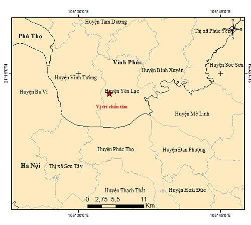
According to the Earthquake Information Center and Tsunami Warning of the Institute of Geophysics (Vietnam Academy of Science and Technology), at 1:09:43 AM (GMT) on March 3, which is 8:09:43 AM (Hanoi time) on March 3, an earthquake with a magnitude of 3.2 occurred at coordinates (21.215° N, 105.554° E), with a focal depth of approximately 16 km. The earthquake struck in Yen Lac District, Vinh Phuc Province. Disaster risk level: Level 0.

Earthquake epicenter map in Vinh Phuc Province. (Source: Institute of Geophysics).
The Earthquake Information Center and Tsunami Warning continue to monitor this earthquake.
Earlier, at 9:49:54 PM (GMT) on March 2, which corresponds to 4:49:54 AM on March 3, an earthquake with a magnitude of 4.4, with a focal depth of about 16 km, occurred at coordinates 22.534° N – 102.672° E, in Mường Tè District, Lai Châu Province, without causing any disaster risk.
On March 1, at 11:24:22 PM, an earthquake with a magnitude of 3.0 occurred in Tuần Giáo District, Điện Biên Province, with a focal depth of approximately 16 km, also without causing any disaster risk.
Nguyễn Xuân Anh, Director of the Institute of Geophysics (Vietnam Academy of Science and Technology), stated that the Earthquake Information Center and Tsunami Warning continue to monitor the seismic activity in this area to provide timely updates to the media and local authorities.
According to Director Nguyễn Xuân Anh, when an earthquake occurs, the authorities and residents in the affected areas must strictly adhere to the regulations outlined in Decision No. 78/2007/QĐ-TTg dated May 29, 2007, by the Prime Minister regarding the establishment of earthquake and tsunami prevention and control regulations.


