Drones equipped with laser technology have unveiled secrets of the Battle of the Bulge, the largest and bloodiest battle that the United States faced in Europe during World War II.
According to a study published on August 15 in the journal Antiquity, drones have revealed 941 traces of the battle, including trenches and bomb craters.
Officially known as the Ardennes Counteroffensive, the Battle of the Bulge took place from December 1944 to January 1945 in eastern Belgium and Luxembourg, as noted by the Royal Museum of the Armed Forces and Military History in Brussels.

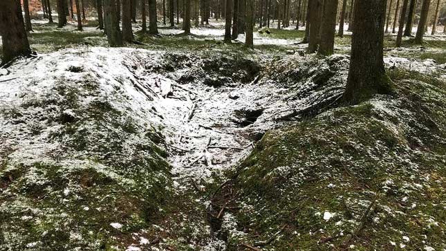
Entrance from the Battle of the Bulge site. (Photo: Stichelbaut, B. et al, Cambridge University Press).
Despite being a significant battle in World War II, the dense forests in the area have concealed much of the archaeological evidence left behind.
To uncover the remnants of the battle, scientists equipped drones with a remote sensing technology called lidar (light detection and ranging), which uses pulsed laser signals to create a digital map of the landscape.
They surveyed the area between the city of St. Vith and the village of Schönberg—once the epicenter of the Battle of the Bulge—and discovered numerous traces of the conflict, including gun emplacements, trenches, and foxholes (small fortifications designed to protect soldiers from enemy fire).
After identifying these features on the virtual map, the researchers visited the sites, helping them to delineate three distinct phases of the Battle of the Bulge. During their survey, researchers found shell casings, gun platforms, and makeshift fortifications believed to be remnants from the pre-attack phase.
When the German offensive began, over 200,000 German troops and nearly 1,000 tanks launched an attack on Allied soldiers. The study’s authors noted that this chaos left behind makeshift fortifications and German artifacts at American artillery depots. This could indicate that German forces utilized abandoned American fortifications during the battle.
The final phase marked a turning point in the battle, characterized by “numerous remaining bomb craters,” which “indicate that Allied air forces were able to establish tactical superiority as the weather improved,” they wrote. However, the researchers added that some of these craters may date back to earlier moments in the battle.
The authors of the study suggest that in the future, this technique could be applied to other forested areas in Europe, enhancing our understanding of various battlefields. It may also aid in the preservation of valuable heritage sites.


