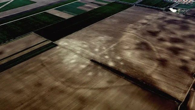
According to a study published on November 10, archaeologists have discovered remnants of an area over 3,000 years old for the first time while examining Google Earth images of a wilderness stretching 150 km along the Tisza River in Serbia.
Satellite images revealed a network of more than 100 Bronze Age structures hidden in the Serbian plains.

Aerial view of agricultural land in Serbia, where Bronze Age settlements existed over 3,000 years ago. (Photo: Barry Molloy and collaborators).
The lead author of the study, Barry Molloy, an associate professor of archaeology at University College Dublin, Ireland, stated: “We can see traces of over 100 settlements from the Late Bronze Age. What is interesting about these sites is that we not only identified their presence in these images but also measured their sizes and understood how people organized the layouts within their settlements.”
He further added: “It is unique in European Bronze Age archaeology to gain such detailed information about numerous settlements in a specific area.”
A Part of a Widespread Trade Network
Previously, this area, known as the Pannonian Plain, was thought to be an uninhabited inland region unsuitable for Bronze Age settlements. However, researchers now believe that it serves as a testament to the many settlements found across Europe, which were part of a widespread trade network at that time.
In addition to analyzing satellite images, for this new research, the team visited the site by small aircraft and discovered traces of dozens of structures “hidden in plain sight.”
Most of the surrounding sites were built close together, similar to modern residential areas, indicating that the inhabitants “chose to live very closely with each other” in what Molloy describes as a “complex and well-organized society.”
“The plots of land are not arranged in any specific straight line but are spread out, separated by several dozen meters,” Molloy explained. “Although we need to excavate to confirm details, we suspect that this was the residence of many extended families.”
Due to farmers having plowed the land for many years, the shapes of many areas are nearly invisible from the ground. However, according to the study, archaeologists have found remnants of some walls and ditches that could have been used as fortifications to help protect the settlements.
Several clues explain why the settlements were fortified so rigorously. Based on the discovery of clay carts and weapons at cemeteries near some surrounding areas, it is likely that the residents here were “familiar with warfare”—not among themselves but with the outside world.
The researchers also excavated a “large quantity” of artifacts, including grinding stones used for processing grain, pottery shards, and bronze pieces, including a pin used for fastening clothing.
Researcher Molloy noted that radiocarbon dating of scattered animal bones in the area has confirmed the ancient existence of this site.
However, archaeologists are uncertain about the reasons that led to the abandonment of the settlement around 1200 BC. “This remains a mystery to this day,” researcher Molloy stated.


