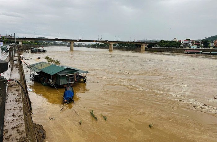
Due to heavy rain, from last night until this morning (October 1), the water levels in the Red River through Lao Cai and Yen Bai rose rapidly, posing a risk of flooding in the low-lying areas along the river in these provinces.
According to the National Center for Hydro-Meteorological Forecasting, last night and this morning (October 1), the Northwest, Viet Bac, Thanh Hoa, and Nghe An regions experienced moderate to heavy rainfall, with some areas receiving very heavy rain such as Ta Giang Phinh (Lao Cai) with 259mm, Mo Vang (Yen Bai) with 206mm, Quang Khe (Bac Kan) with 147mm, and Nga Son (Thanh Hoa) with 254mm…

Flood on the Red River section through Lao Cai city rising rapidly on the morning of October 1 – (Photo: Lao Cai Newspaper).
Mr. Phung Tien Dung, head of the hydrological forecasting department at the National Center for Hydro-Meteorological Forecasting, reported that the flood levels on the Thao River (a tributary of the Red River) were rising quickly this morning.
As of 7 AM today, the water level on the Thao River at Lao Cai was above warning level 1 by 0.04m, while at Yen Bai it was below warning level 1 by 2.97m.
From today until October 2, the water level in the Thao River is expected to continue rising rapidly.
During this flood event, peak flood levels on smaller rivers in Lao Cai and Yen Bai provinces could reach warning levels 2 to 3, with the water level at Yen Bai projected to reach level 2 (with a planned discharge from the Dong Sung Hydropower Plant of 2,500m3/s).
There is a high risk of flooding in the low-lying areas along the river in Lao Cai, Yen Bai, Ha Giang, Tuyen Quang, and potential flash floods and landslides in the mountainous regions of Northern Vietnam.
The meteorological agency forecasts that this morning, the Northwest, Viet Bac, Thanh Hoa, and Nghe An regions will experience rain, moderate rain, and scattered thunderstorms, with localized heavy rain of 10-30mm and some areas exceeding 60mm.
Thunderstorms may bring the possibility of whirlwinds, lightning, hail, and strong gusts of wind.
From the afternoon of October 1 until October 2, the area from South Nghe An to Thua Thien Hue is expected to receive moderate to heavy rain and thunderstorms, with localized heavy downpours ranging from 30-70mm, and some areas exceeding 150mm.
There is a warning for the possibility of localized heavy rainfall exceeding 100mm in 6 hours. Intense rainfall and localized heavy rain could lead to flooding in low-lying areas, urban areas, flash floods in small rivers and streams, and landslides on steep slopes.
The meteorological agency recommends that local authorities regularly monitor and update hydro-meteorological forecasts and warnings, review bottleneck points, and identify areas at risk of flash floods and landslides, especially in vulnerable locations, to take preventative and responsive measures.
Due to heavy rain linked to the remnants of Typhoon No. 3, from September 8-9, water levels on many rivers and streams in Northern Vietnam have risen rapidly.
Notably, the water level on the Red River has exceeded warning level 3. The flood levels on the Red River at Lao Cai and Yen Bai have surpassed historical flood peaks that existed for 53 years.
The peak flood level at the Lao Cai station is 3.47m, above warning level 3; at Bao Ha, it is 4.95m, exceeding the historical flood level of 2008 by 1.02m. In Yen Bai, the peak has reached above warning level 3 at 3.73m, exceeding the historical flood level of 1968 by 1.31m.


