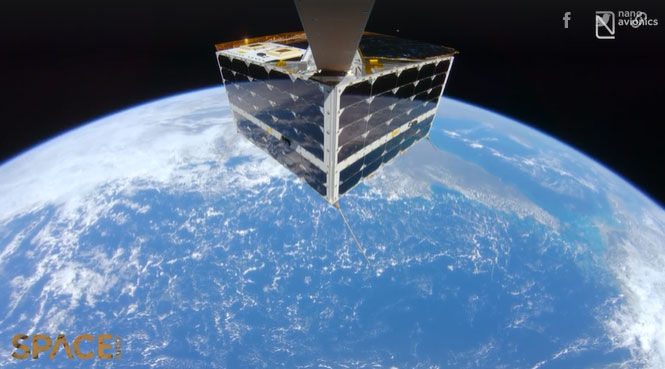
The MP42 satellite uses a selfie stick to capture images of itself against the backdrop of the Great Barrier Reef, a coral reef spanning 344,400 km² off the coast of Australia.
Video: NanoAvionics
NanoAvionics, a satellite company based in the USA and the UK, released a 4K resolution video on June 28, showcasing the MP42 satellite flying 550 km above the Great Barrier Reef and Coral Sea in northeastern Australia. The video was captured with the help of a selfie stick and is the first to feature the entire satellite with Earth as a background at such high resolution, according to NanoAvionics.
The choice of the coral reef as a backdrop was intentional. “We want to highlight the vulnerability of our blue planet and the importance of satellite Earth observation, especially in monitoring environmental and climate changes,” said Vytenis Buzas, co-founder and CEO of NanoAvionics.
The Great Barrier Reef is the largest structure on the planet formed by living organisms, covering approximately 344,400 km2, according to NASA’s Jet Propulsion Laboratory (JPL). In 2016, the agency studied the Great Barrier Reef under the mission “CORAL in the air” to provide a more comprehensive dataset on the damages the corals are facing.

The MP42 satellite captures a selfie video above the Great Barrier Reef.
Coral reefs around the world, including the Great Barrier, are showing signs of decline amid global warming driven by human activities. Coral reefs are “deteriorating at an alarming rate,” JPL noted.
In addition to its environmental significance, NanoAvionics’ selfie video also provides technical benefits. During the filming, the MP42’s camera tested and verified the operations of a control system used to process some data in space before transmitting it back to Earth. This process saves time when assessing rapidly changing areas around the globe.
The MP42 was launched into orbit alongside approximately 40 other small satellites aboard SpaceX’s Falcon 9 rocket on April 1, during the mission named Transporter-4. NanoAvionics anticipates that the footage from the satellite, including live broadcasts and recorded videos, will have various applications in the future, such as activity verification, fault detection, impact assessment of small meteoroids, and educational purposes.


