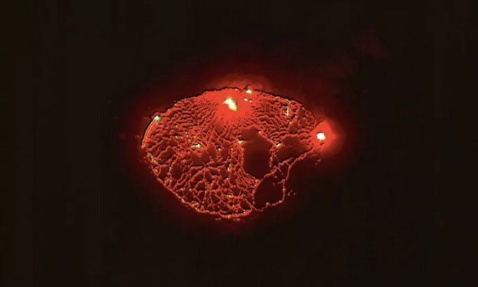
The WorldView-3 and WorldView-2 Satellites from Maxar Technologies in the United States captured stunning images of lava erupting from Kīlauea volcano in Hawaii on September 30 and October 1.
The photos shared by Maxar Technologies on Twitter on October 1 show a bright red glow around the active volcano’s crater. According to a statement from the United States Geological Survey (USGS) on October 6, lava continues to erupt from two vents, one located along the base of the volcano and the other on the western wall of the Halema’uma’u crater. All lava eruption activity is confined within the Halema’uma’u crater at Hawaii Volcanoes National Park. Seismic activity and gas emissions from the volcano are also on the rise.

WorldView-2 satellite captures an image inside Kīlauea volcano in Hawaii on October 1. (Photo: Maxar Technologies)
Kīlauea Volcano began erupting on September 29. The USGS continues to monitor this volcano due to high levels of volcanic gases such as steam, carbon dioxide, and sulfur dioxide. When these gases are released into the atmosphere, they can create fog that poses health risks to humans, pets, and crops. Additionally, glass fragments that can irritate the skin and eyes from the volcano can be carried by the wind for hundreds of meters. Authorities have restricted access to the area around the crater since early 2008.
Kīlauea, a shield volcano with gently sloping sides formed by thin lava layers, erupts periodically. Scientists are closely monitoring the recent eruption and have determined that it does not pose an immediate threat to nearby communities.
The WorldView-2 and WorldView-3 satellites have been operating in low Earth orbit since 2009 and 2014, respectively. WorldView-2 observes the Earth from an altitude of 772 km, while WorldView-3 operates at an altitude of 617 km. In comparison, the International Space Station flies at an average altitude of 400 km. Both satellites follow a Sun-synchronous orbit, capturing color images and passing over each area on Earth once a day.


