Seismometers can detect earthquakes or volcanic eruptions, which can trigger tsunamis. However, only a few large earthquakes cause events of this magnitude; thus, a warning system based solely on seismic data can easily lead to false alarms.
Scientists require additional devices at sea to aid in detection. These include two main types: Pressure sensors on the ocean floor and Tide gauges that monitor sea levels along the coast.
 |
|
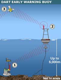
Dart Warning System. |
The Tsunami Warning and Assessment System (DART) utilizes buoys and sensors placed far offshore.
A seabed pressure sensor measures the height of the water column above it—changing with wave height—and sends a signal to a buoy on the surface. This buoy monitors surface conditions and relays the information it gathers—along with data from the seabed—to a satellite, which forwards it to a ground receiving station.
Germany is collaborating with Indonesia on a project to deploy 10 buoys in this region of the Indian Ocean. The first two were installed last November. India, Thailand, and Australia are also expected to install DART buoys along the Sunda Trench—the area where the earthquake that triggered last year’s devastating tsunami occurred on December 26.
 |
|
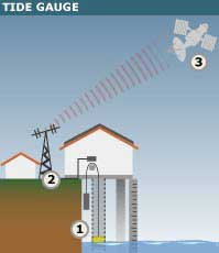
Tide Gauge. |
The advantage of the DART system is its ability to detect tsunamis from far offshore, providing sufficient time to alert countries in the region. However, the cost of installing and operating such buoys is very high.
Meanwhile, the Intergovernmental Oceanographic Commission (IOC) of UNESCO is focusing on a network of tide gauges.
Unlike DART buoys, tide gauges in the Global Sea Level Observing System (GLOSS) are located on land—either on the coast of large continents or on offshore islands. The most basic type of gauge observes water surface levels using a system of tubes and buoys. More modern designs “shoot” radar or ultrasonic waves down to the water surface from above, or utilize seabed pressure sensors connected to surface observation stations via a cable.
Currently, there are nearly 70 GLOSS stations in the Indian Ocean. Before last year’s tsunami, they were used to measure sea levels in long-term climate change studies, with data transmitted periodically. However, they have now been upgraded to send real-time information via satellite to newly established national tsunami warning centers.


