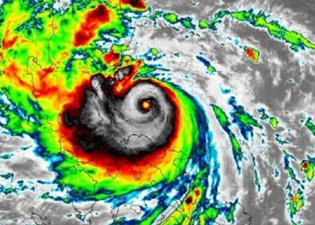
According to the Ha Tinh Hydro-Meteorological Station, at 7 AM this morning, the center of Typhoon USAGI was located over the waters north of Luzon Island (Philippines); the maximum wind speed near the center of the typhoon reached level 12 (117-133 km/h), with gusts up to level 15.
This morning (November 15), the tropical depression (weakened from Typhoon No. 8) has deteriorated into an area of low pressure over the northwestern waters of the North China Sea.
At 7 AM, the center of the low-pressure area was located at approximately 21.0 degrees North latitude; 113.0 degrees East longitude. The maximum wind speed at the center of the low-pressure area has decreased to below level 6 (below 39 km/h).
Forecast for the next 12 hours, this low-pressure area is expected to continue moving southwest and gradually weaken and dissipate.
Typhoon USAGI has gusts up to level 15.
Meanwhile, at 7 AM this morning, the center of Typhoon USAGI was positioned at approximately 20.0 degrees North latitude; 120.3 degrees East longitude, over the waters north of Luzon Island (Philippines). The maximum wind speed near the center of the typhoon reached level 12 (117-133 km/h), with gusts up to level 15. It is moving northwest at a speed of about 20 km/h.
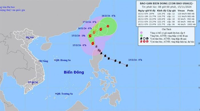
Movement direction of Typhoon USAGI at 8 AM on November 15, 2024.
Forecast for the typhoon’s development in the next 24 to 72 hours is as follows:
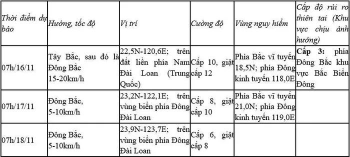
Due to the impact of the typhoon, the northeastern waters of the North China Sea will experience strong winds of level 8-9, with winds near the center reaching levels 10-12, gusting to level 15, and waves rising to 3.0-5.0 meters, with waves near the center reaching 5.0-7.0 meters; the sea will be extremely rough.
Vessels operating in these dangerous areas may be affected by thunderstorms, tornadoes, strong winds, and large waves.
