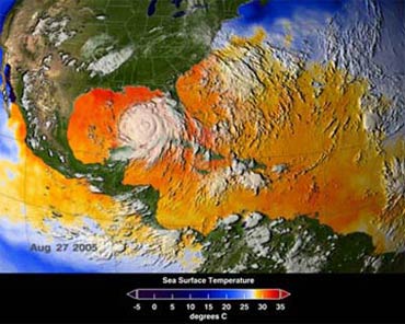
If you browse through American websites discussing Hurricane Katrina, you’ll find a technology that was utilized throughout the storm’s journey. This technology is GIS (Geographic Information System). It described the nature of the storm, forecasted its path, assessed its impact, and significantly aided in addressing the aftermath. Can this technology be applied in Vietnam?
 |
|
A GIS system demonstrating a wide-scale temperature model. |
Predicting and Mitigating Natural Disasters
GIS, or Geographic Information System, can be understood as a remarkable “marriage” between Information Technology and the field of Geography. However, with the development and versatility of GIS today, this technology has a much broader definition. By integrating information about Natural phenomena, Socio-economic factors, and various other data, users can generate “products” tailored to their specific needs.
GIS has been around for a long time and is extensively applied in all areas of life in developed countries. With a few online mapping tools like Google Earth (www.earth.google.com.vn), you can observe the globe and zoom in to specific routes to supermarkets in New York or get directions to any location within cities across the United States, or even view the Eiffel Tower in Paris…
However, we want to first address the application of GIS in disaster prevention and management of natural disasters in general—this is an application of GIS in the field of meteorology and hydrology. Numerous studies on the application of GIS in creating flood maps or forecasting floods can be found online. You can refer to: http://www.gisdevelopment.net/application/natural_hazards/floods/ma03138.htm or http://www.gisdevelopment.net/aars/acrs/1999/ts14/ts14106.shtml.
Why is it that Vietnam, a country that faces constant threats from natural disasters and annual flooding, suffering significant losses in terms of life and property, has not seen the widespread or specific application of this technology as is seen around the world? Is GIS technology too advanced? Too complex? Or is it merely a common and versatile technology that can be applied across various fields, accessible for every citizen to use easily?
Long ago, workshops on GIS in Vietnam pointed out that the widespread application of GIS in the country would bring tremendous benefits and is highly urgent. One of the clearest examples is the aftermath of Typhoon No. 7 and flash floods in Van Chan (Yen Bai).
For instance, a GIS map created in the mountainous region of Yen Bai can identify factors such as the degree of deforestation, slope, and area of mountain slopes… From this information, computers can calculate and predict areas at high risk of landslides and flash floods, estimating how much rainfall and over what duration these events could occur. From these predictions, local authorities can relocate communities away from danger zones or issue early warnings about potential disasters.
GIS – A Versatile and Common Digital Technology
Not only used for disaster prevention, GIS is a versatile digital technology with significant applications across many fields and daily activities.
 |
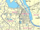
| The GIS system in Hanoi and major cities will soon become familiar to every Vietnamese citizen?! |
Have you ever imagined visiting Hanoi but not knowing where to go or what transportation to use? You could simply click your mouse, and the computer would provide you with an online map of Hanoi, allowing you to find and access complete information about the locations you need to visit, and the computer would also suggest which mode of transport to take and the route schedule, etc. This is already commonplace in European cities and will soon become familiar in Vietnam.
GIS has been present in almost all fields of science and technology and social life since the 1970s. This technology is not new in the world or in Vietnam, but public awareness and application of it still have many limitations.
In the environmental field, GIS is used to analyze and model processes of soil erosion and the spread of pollution in air or water.
In agriculture, GIS is a powerful tool for monitoring harvests, managing land use, forecasting products, conducting soil studies, planning irrigation, and checking water sources.
In the finance sector, GIS has been used to identify locations for new bank branches. Its use in this field is increasing as it serves as a tool for risk assessment and insurance purposes, accurately identifying areas with the highest or lowest risk.
Apart from applications in evaluation and management, GIS can also be used in the healthcare sector. For example, it can indicate the quickest route from an ambulance’s current location to a patient in need based on traffic data. GIS can also serve as a research tool for analyzing the causes of outbreaks and the spread of diseases within communities.
For local managers, the application of GIS is very effective because it utilizes spatial data extensively. All local government agencies can benefit from GIS; it can be used for land search and management, replacing existing paper documentation. Local officials can also use GIS for maintaining buildings and roadways. GIS is also employed in control centers for managing emergency situations.
In sectors such as transport, electricity, gas, and telecommunications, GIS is enormously flexible; it is used to build databases and is a key factor in the IT strategy of companies in these fields.
 |
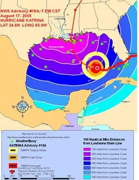
| A GIS system for Hurricane Katrina includes all elements for analyzing trends and subsequent impacts… |
A specific example is the recent Hurricane Katrina in the United States, where GIS technology was utilized for hurricane research, modeling, forecasting, and particularly in addressing the aftermath of the storm. You can learn more about the versatility of this technology on several websites: http://www.Esri.com or http://www.gis.com.
In Vietnam, GIS has also been applied for a long time and in many fields. Previously, GIS was primarily used in research institutes, centers, or universities. However, it is now beginning to become widespread in various areas of life, as learning and using this technology is as simple as using any common software program we currently use. One of the places where this technology is taught in Vietnam is VidaGIS (www.vidagis.com), with many government agencies and localities conducting research and applying GIS, such as the University of Science in Ho Chi Minh City, the Ministry of Science and Technology, and the Ministry of Natural Resources and Environment… It is certain that soon, GIS will become an indispensable part of the needs of every citizen.
For more details, you can visit some specialized websites for GIS training and research in the world and Vietnam: www.esri.com, www.gisworld.com, www.gis.com, vidagis.com, www.nea.gov.vn…
The Phong


