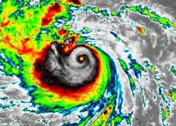
Typhoon Yinxing, with wind speeds of 149 km/h (Category 13), is currently located to the northeast of Luzon Island in the Philippines and is expected to enter the South China Sea on November 8.
The National Center for Meteorological Forecasting reports that the typhoon is moving northwest at a speed of 15 km/h. It is forecasted to strengthen to Category 14 by 10 AM tomorrow, with maximum wind speeds reaching 166 km/h, experiencing gusts that can increase by three levels.
After passing Luzon Island, the typhoon will enter the South China Sea on November 8, maintaining a strength of Category 13 and heading towards the Paracel Islands of Vietnam.
Japanese meteorological services predict that Typhoon Yinxing will enter the South China Sea on November 8 and reach peak strength with wind speeds of 144 km/h. Hong Kong meteorologists indicate that since the typhoon will pass close to the northern coast of Luzon, it will continue to have strong winds of 155 km/h upon entering the South China Sea.

Forecast path and affected areas of Typhoon Yinxing on November 6. (Photo: NCHMF).
Mr. Vu Anh Tuan, Deputy Head of the Weather Forecasting Department at the National Center for Meteorological Forecasting, stated that when entering the South China Sea, the typhoon will maintain strength between Categories 12 and 13. As it moves further in, it will encounter cooler air, and with decreasing sea surface temperatures and changing environmental conditions, the storm’s intensity may fluctuate.
Regarding the movement direction, Mr. Tuan indicated that from November 8 to 10, the typhoon will head west-northwest before shifting southwest towards the Paracel Islands.
The impact of the typhoon will be significant, with strong winds of levels 6-7 expected in the eastern waters of the northern South China Sea. From the evening and night of November 7, winds will increase to levels 8-10, while areas close to the eye of the typhoon could experience winds of levels 11-13 with gusts up to level 16. Waves could reach heights of 4-6 meters, and up to 6-8 meters near the center. Vessels operating in these areas may be affected by thunderstorms, whirlwinds, strong winds, and high waves.
Since the beginning of the year, there have been six typhoons in the South China Sea. The most recent was Typhoon Trà Mi, which hit Thừa Thiên Huế – Đà Nẵng on October 27, causing heavy rains in Central Vietnam. This resulted in 8 fatalities, 14 injuries, nearly 330 damaged homes, over 1,200 hectares of crops destroyed, and 1,500 livestock lost or swept away.
In September, the Institute of Meteorology, Hydrology, and Climate Change predicted that there would likely be about 4-5 more typhoons in the South China Sea and 2-3 that would affect the mainland of Vietnam in the remaining months of this year.


