NASA Utilizes Satellite Data to Map Earthquake Damage in Southern Turkey
On February 6, 2023, powerful earthquakes measuring 7.8 and 7.5 on the Richter scale struck Turkey and Syria, causing widespread devastation in both countries. The quakes originated from a fault line located 18 kilometers beneath the surface, generating intense tremors that affected areas hundreds of kilometers away from the epicenter, according to new data shared by NASA on February 10.

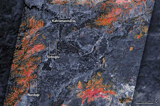
Satellite map of earthquake damage in southern Turkey. (Photo: NASA).
“These are very large and powerful earthquakes, breaking the entire surface across a series of long fault segments,” said geophysicist Eric Fielding at NASA’s Jet Propulsion Laboratory. “This generates extremely strong shaking over a very vast area, impacting many populous cities and towns. The length and intensity of the 7.8 magnitude earthquake are similar to the 1906 earthquake that devastated San Francisco.”
Immediately after news of the disaster spread, NASA scientists along with space agencies worldwide swiftly collected, processed, and analyzed satellite data related to the incident.

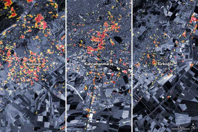
Map of earthquake damage in Türkoğlu, Kahramanmaraş, and Nurdağı. (Photo: NASA)
The preliminary damage map above shows parts of the Turkish cities of Türkoğlu, Kahramanmaraş, and Nurdağı, where dark red pixels indicate areas with severe damage to buildings and infrastructure or significant alterations to the landscape, while orange and yellow areas show moderate or partial destruction. Each pixel measures approximately 30 meters, equivalent to the size of a baseball field.
This map was created from data collected by the PALSAR-2 instrument on the Advanced Land Observing Satellite-2 (ALOS-2) on February 8, 2023. This satellite is equipped with synthetic aperture radar, a sensor that sends microwave pulses towards the Earth’s surface and listens for the reflections of those waves to map the landscape. By comparing data from February 8 with observations from the same satellite prior to the earthquake (on April 7, 2021, and April 6, 2022), scientists could identify changes and determine the damaged areas.
ALOS-2 data is provided by Sentinel Asia (an international collaborative project aimed at applying remote sensing technology and Web-GIS to support disaster management in the Asia-Pacific region) and is analyzed in coordination with the Earth Observatory at Singapore’s Remote Sensing Laboratory, NASA’s Jet Propulsion Laboratory, and the California Institute of Technology.
“The map only shows the central part of the affected area since ALOS-2 uses a narrow beam data strip covering 70 km, but it includes the epicenters of both the main 7.8 magnitude earthquake and the 7.5 magnitude aftershock,” Fielding noted.
The damage map and satellite data are being shared with organizations such as the U.S. Department of State, the Miyamoto Global Disaster Relief, and the World Bank. The NASA team is also participating in ongoing coordination programs organized by the U.S. Agency for International Development to contribute scientific expertise in support of recovery efforts. As new data becomes available, the NASA team will update the maps in near real-time.
“We are closely monitoring this event. In addition to mapping satellite damage, we are using satellites to monitor increased landslide risks, power outages, and severe weather that could pose challenges to response efforts,” added Shanna McClain, program manager for collaboration.


