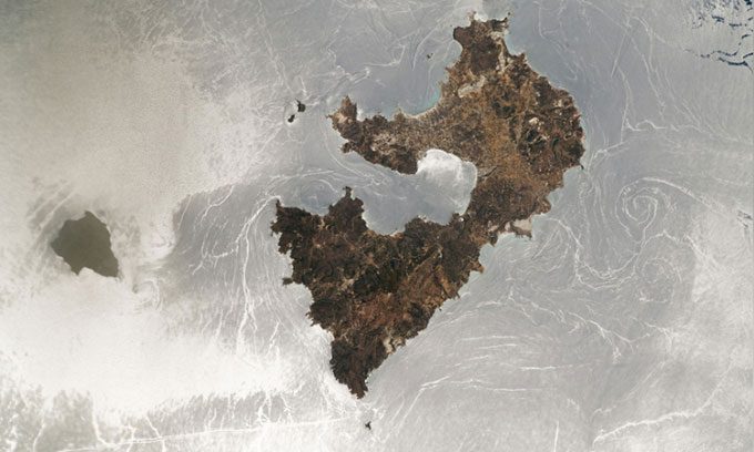
Astronaut Captures “Sunglint” – A Phenomenon Caused by Sunlight Reflecting Off Calm Ocean Waters to the Camera – Over the Waters of Greece.
An astronaut from Expedition 67 aboard the International Space Station (ISS) captured an intriguing photo of the “sunglint” phenomenon, where the ocean surface transforms into a giant silver mirror. This phenomenon occurs when sunlight reflects off the calm sea and reaches the astronaut’s camera. NASA’s Earth Observatory released the photo on September 12.

Astronaut on the International Space Station (ISS) captures “sunglint” – a phenomenon that turns the waters surrounding the Greek islands into a silver mirror. (Photo: NASA Earth Observatory)
The image was taken with a digital camera pointing out from a window of the ISS on June 25. The large landmass in the center is Milos, a volcanic island spanning 151 km2 in Greece. The small, uninhabited landmass to the left is Antimilos, approximately 8 km2 in size. The silver waters surrounding the islands include the Myrtoan Sea to the northwest of Milos and the Sea of Crete to the southwest, both of which are part of the Mediterranean Sea.
In the photo, the ripples and eddies that resemble scratches on a mirror are actually currents on the surface and deeper below the ocean, as well as rarer phenomena such as internal waves and gyres. Most of these features are typically not visible from space, but they become more noticeable in sunglint due to the scattering of sunlight.
One of the most prominent structures is the gyre to the right, east of Milos, which appears similar to a large whirlpool from above. However, unlike a whirlpool that pulls everything down, the gyre plays a crucial role in maintaining ocean currents – a factor that helps circulate nutrients in the ocean – in the surrounding area, according to the National Oceanic and Atmospheric Administration (NOAA).
Another notable structure is the long straight streak at the bottom left of the image. This is likely a wake from a fast-moving ship on the ocean surface, according to NASA’s Earth Observatory.
However, the most interesting structure in the image may be the series of parallel lines offshore from the northeastern coast of Antimilos. These lines, mostly obscured by clouds surrounding the island, are internal waves – large waves that travel vertically and propagate through the water from below the surface. Unlike surface waves, which primarily form due to currents or strong winds, internal waves result from gravitational waves.
Researchers also use sunglint images to monitor oil spills, as oil slicks on the ocean surface reflect less light than water, according to NOAA. However, for marine scientists who need satellite images to monitor algal blooms or ocean color, sunglint can be a nuisance. Therefore, these scientists often have to remove sunglint from satellite images.


