Researchers Utilize High-Resolution Radar Data to Discover Submarine Volcanoes Across the World’s Oceans

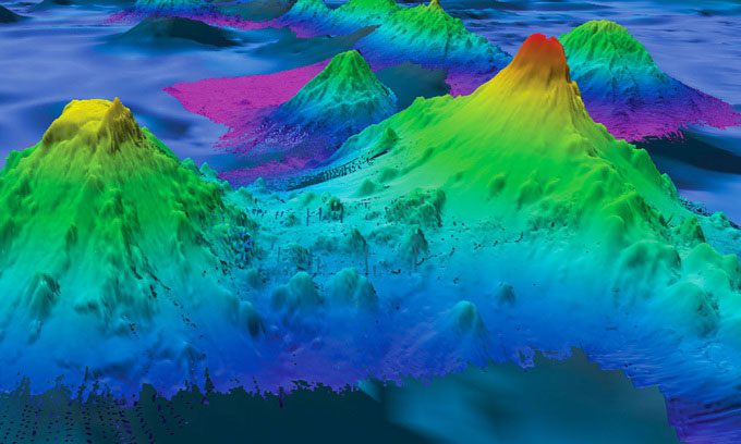
Pao Pao Seamount, 4,776m high (right) in the South Pacific, is among the mountains mapped using sonar. (Photo: Ocean Exploration and Research Office, National Oceanic and Atmospheric Administration (NOAA))
The radar data used in this new research can detect very subtle signs of seawater pooling above submarine volcanoes, caused by the gravitational pull of the mountains. Most of these underwater volcanoes have not yet been mapped using sonar (Sound Navigation and Ranging), Interesting Engineering reported on April 20. The newly published catalog of submarine volcanoes appears in the journal Earth and Space Science.
Previously, only a quarter of the ocean floor had been mapped using sonar, leaving scientists uncertain about the number of submarine volcanoes that exist. However, the new study utilized high-resolution radar data, including data from the European Space Agency’s CryoSat-2 satellite and the SARAL satellite from the space agencies of India and France, to locate submarine volcanoes that are 1,100 meters or taller.
According to marine geophysicist David Sandwell, who led the study, the new findings are astonishing. Submarine volcanoes pose a hazard to shipping, but they also contain rare earth elements and have become commercial targets for deep-sea mineral operators.
Submarine volcanoes also serve as vital oases for marine life. Their steep slopes are home to corals and many other organisms. Additionally, they hold information about tectonic plates and magma activity, and play a role in controlling major ocean currents that help isolate large amounts of heat and CO2.
According to Larry Mayer, director of the Center for Coastal and Ocean Mapping at the University of New Hampshire, the new catalog of submarine volcanoes represents an important advancement. This catalog could be beneficial for research on ecology, tectonics, and ocean mixing. John Lowell, a scientist at the National Geospatial-Intelligence Agency (NGA), stated that a better understanding of seafloor shapes will aid in responding to climate change.


