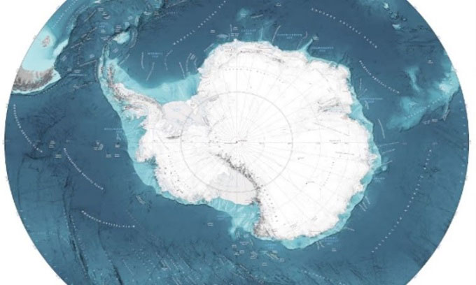
A group of scientists has released the most detailed map of the seabed of the Southern Ocean surrounding Antarctica, covering an area of 48 million square kilometers along with the deepest point in the region.
Named the International Bathymetric Map of the Southern Ocean (IBSCO), this latest map not only aids ships in safe navigation at sea but also provides scientists with valuable research tools to better understand the environment, weather, and climate in the area. The new map extends 10 degrees further north than the previous one and encompasses an area 2.4 times larger. Divided into 500-meter squares, 23% of the squares on the map are constructed from at least one modern sonar depth measurement.

IBSCO is the most accurate map of the Southern Ocean. (Photo: BAS)
Notably, the new map includes the Factorian Deep, the deepest point ever known in the Southern Ocean. At a depth of 7,432 meters, this point is located in the South Sandwich Trench, about 100 kilometers east of the islands of the same name. Factorian Deep was discovered in 2019 by the manned submersible DSV Limiting Factor, led by expedition leader Victor Vescovo.
Despite numerous international efforts since the HMS Challenger expedition in 1873, the seabed of the oceans remains a significant mystery. According to the National Oceanic and Atmospheric Administration (NOAA), only 10% of the seabed has been mapped using sonar methods. Most of the maps we see are based on incomplete, low-resolution data.
This is not surprising, as water covers three-quarters of the Earth’s surface, and the deepest point underwater reaches 10,984 meters. The seabed is constantly changing at a rapid pace, requiring organizations like NOAA and the Royal Navy to frequently deploy survey ships to ensure navigational maps are always up to date. Many depth surveys, such as those conducted by the RRS James Clark Ross from the British Antarctic Survey, require additional support from commercial and research vessels.
“This map is significant for scientific research,” said Rob Larter, a geophysicist at BAS and co-author of the map. “It will help us understand how the shape of the seabed influences the flow of ocean currents and how seawater mixes, thereby affecting the transport of heat and temperature globally. This is an extremely important factor in predicting climate change.”


