With strong winds of level 8, gusting up to level 10, Typhoon No. 8 is expected to make landfall in the Thanh Hóa – Quảng Bình area on October 14. The Northern and Central regions will begin experiencing heavy rain starting this afternoon, October 13.
On the morning of October 13, the National Center for Hydro-Meteorological Forecasting reported that Typhoon No. 8 has been intensifying in recent hours. At 4 AM, the eye of the typhoon was located 270 km northeast of the Paracel Islands. The maximum wind speed reached level 11, with gusts of level 14. Today and tonight, the typhoon will move quickly westward at a speed of 25-30 km/h and will enter the southern part of the Gulf of Tonkin. After this time, the typhoon is expected to gradually weaken in intensity. By the morning of October 14, it will still maintain winds of level 9, with gusts of level 11.
Afterward, the storm will continue on its current path, slowing down to 20 km/h and moving deeper inland from Thanh Hóa to Quảng Bình, eventually weakening into a tropical depression.
The danger zone in the East Sea over the next two days will be north of latitude 15.5 degrees north and west of longitude 111 degrees east. All vessels operating in this high-risk area will be affected by strong winds, high waves, and tornadoes.
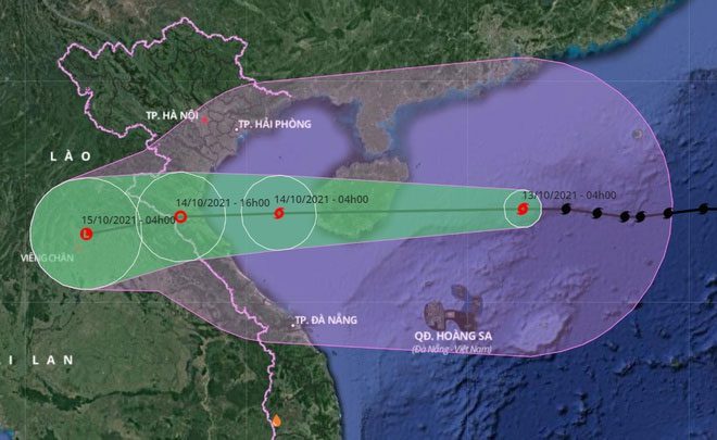
Typhoon No. 8 is heading straight towards the inland areas of Thanh Hóa – Quảng Bình at a speed of 20-30 km/h. (Photo: VNDMS).
Starting tonight (October 13), coastal areas from Quảng Ninh to Quảng Bình will experience increasing winds of level 6-7, with gusts up to level 9. Due to the interaction with cold air, some places in the northern region of the typhoon’s circulation will see winds of level 8, with gusts of level 10.
From the afternoon of October 13 to the end of October 15, the Northern region and Quảng Trị will experience heavy rain with rainfall amounts typically between 100-150 mm per event, and some places exceeding 200 mm. Meanwhile, areas from Thanh Hóa to Quảng Bình will see very heavy rainfall, ranging from 200-300 mm per event, with some places exceeding 350 mm.
The mountainous areas are at high risk of flash floods and landslides, while low-lying regions and riverbanks may experience localized flooding. From October 16, due to the influence of strengthened cold air combined with a tropical convergence zone, Central Vietnam will continue to have the potential for heavy to very heavy rain.
In the northern part of the East Sea (including the waters around the Paracel Islands), winds will be strong at levels 8-9, near the eye of the storm reaching levels 10-11, with gusts of level 14. Sea waves will be 5-7 meters high.
In the Gulf of Tonkin (including Bạch Long Vĩ Island) and the waters from Quảng Trị to Quảng Ngãi (including Cồn Cỏ Island), winds will be strong at levels 6-8, with areas near the eye of the storm reaching level 9, gusting to level 11. Waves will be 3-5 meters high.
Experts warn that coastal areas of provinces and cities from Thái Bình to Hà Tĩnh should be cautious of storm surges of 0.4-0.6 meters, combined with high tide, which could cause flooding in low-lying areas on the morning of October 14.
On October 13, the central and southern East Sea (including the waters around the Spratly Islands) and the waters from Bình Thuận to Cà Mau will experience strong southwest winds of level 6, with gusts of level 8. Sea waves will be 2-4 meters high.
In an urgent telegram sent by the Prime Minister to ministries, sectors, and localities from Quảng Ninh to Quảng Ngãi on the afternoon of October 12, it was emphasized that Typhoon No. 8 is strong over the sea, moving very quickly, with a wide area of impact.
The typhoon’s circulation and cold air are likely to cause heavy, prolonged rain in the provinces and cities of Northern and Central Vietnam, especially in the North Central region and Quảng Trị, Quảng Nam. These localities have already experienced heavy rainfall recently, with many small reservoirs filled, posing a high risk of flash floods and landslides in mountainous areas and flooding in low-lying regions.
To proactively respond to the typhoon, flash floods, and landslides, and to minimize damage to life and property, the Prime Minister has requested relevant units, ministries, sectors, and localities to ensure safety for vessels operating at sea, river mouths, and in anchorage areas; and to ensure the safety of people in aquaculture cages and on islands.
Localities need to proactively review and evacuate residents in dangerous areas, especially where there is a risk of flash floods and landslides, and implement measures to protect dikes, reservoirs, and agricultural production; arrange forces, materials, machinery, and equipment to be ready to respond and recover in case of incidents.
