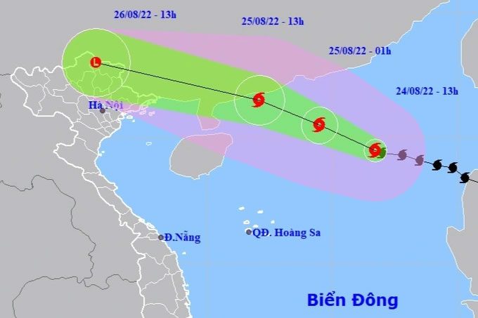
According to experts, Typhoon No. 3 (Typhoon Maon) could reach a strength of level 12, with gusts up to level 15. Typhoon No. 3 is expected to follow two potential movement scenarios, both of which will bring heavy rainfall to northern regions.
Mr. Nguyen Van Huong, Head of the Climate Forecasting Department at the National Center for Hydro-Meteorological Forecasting, stated that Typhoon No. 3 is a strong storm with a very fast movement speed.
Discussing the possible movement scenarios of this typhoon in the coming hours, Mr. Huong noted: The most likely scenario currently (with an 80% probability) is that the typhoon will move rapidly in a west-northwest direction toward the southern part of Guangdong Province (China), then continue west-northwest into the southwestern region of Guangdong, moving further inland, weakening, and dissipating.
In addition to the above scenario, another possible scenario for Typhoon No. 3 (with a probability of about 10-20%) is that the typhoon could make landfall in the northern part of Leizhou Peninsula (China), then move into the northern Gulf of Tonkin. In this scenario, the Gulf of Tonkin and the inland provinces of northern Vietnam will experience stronger impacts from Typhoon No. 3, with heavy rain and strong winds.
However, according to Mr. Huong, both scenarios will result in heavy rainfall across the inland provinces of northern Vietnam, albeit to varying degrees.

Location and movement direction of Typhoon No. 3. (Photo: NCHMF).
According to the National Center for Hydro-Meteorological Forecasting, at 1 PM on August 24, the center of the typhoon was located at approximately 19.5 degrees North latitude and 116.7 degrees East longitude, over the northern part of the South China Sea, about 420 km southeast of Hong Kong (China). The maximum wind speed near the center of the typhoon was level 11 (103-117 km/h), with gusts up to level 14. The radius of strong winds at level 6, with gusts at level 8, extends about 170 km from the center of the typhoon.
Forecast for the next 24 hours, the typhoon will move in a west-northwest direction at a speed of 20-25 km per hour. By 1 PM on August 25, the center of the typhoon is expected to be located at approximately 21.5 degrees North latitude; 112.1 degrees East longitude, over the waters southwest of Guangdong Province (China), about 450 km east of Mong Cai (Quang Ninh). The maximum wind speed near the center of the typhoon is expected to remain at level 11 (103-117 km/h), with gusts up to level 14.
The danger zone in the South China Sea over the next 24 hours (winds of level 6 or higher, gusts of level 8 or higher): north of latitude 17.5 degrees North; from longitude 110.0 to longitude 118.5 degrees East. All vessels operating in this danger zone are at high risk of being affected by strong winds, large waves, and tornadoes. The level of natural disaster risk is rated at level 3.
In the next 24 to 48 hours, the typhoon will continue moving in a west-northwest direction at a speed of 25 km per hour and will weaken into a tropical depression, and then further weaken into an area of low pressure. The maximum wind speed at the center of the low-pressure area will drop below level 6 (less than 39 km/h).
The danger zone at sea in the next 24 to 48 hours (winds of level 6 or higher, gusts of level 8 or higher): north of latitude 19.0 degrees North; west of longitude 114.5 degrees East. All vessels, aquaculture areas, and activities in this danger zone are at high risk of being impacted by strong winds, large waves, and tornadoes. The level of natural disaster risk is rated at level 3.
Warnings of strong winds and large waves at sea: Due to the impact of the typhoon, the eastern and northern waters of the North South China Sea will experience rainstorms, with wind speeds reaching levels 7-8, increasing to levels 9-10, and near the center of the typhoon reaching levels 11-12, with gusts up to level 15; wave heights will be between 6.0-8.0 meters; the sea will be very rough.
In the northern part of the Gulf of Tonkin (including the islands of Bach Long Vi and Co To) from around noon on August 25, winds will gradually increase to level 5, then rise to levels 6-7, with gusts up to level 9, and wave heights between 2.0-3.0 meters. The sea will be very rough.
Warnings of strong winds on land: From the evening of August 25, the coastal areas of Quang Ninh – Hai Phong may experience strong gusts of level 6-7.
Warnings of heavy rainfall: From the afternoon of August 25 to the night of August 26, heavy rain is expected in the northern regions, with some areas experiencing very heavy rain and thunderstorms accompanied by strong gusts, with rainfall generally between 100 – 200 mm, and some places exceeding 250 mm; Thanh Hoa will see 50-100 mm, with some areas exceeding 150 mm.


