Long before Hurricane Ida made landfall in southern Louisiana on August 26, meteorologist David Keellings was deeply alarmed by the storm’s strength.
As the hurricane swept across the western tip of Cuba and moved through the Gulf of Mexico, Keellings, an assistant professor at the University of Florida, realized that Ida would become fierce and frightening. As the storm began to traverse the unusually warm waters of the Gulf of Mexico (with some areas reaching temperatures of up to 30 degrees Celsius, even at depths greater than 30 meters), conditions deteriorated rapidly. In the following 24 hours, the storm underwent rapid intensification, escalating from a Category 1 to a Category 4 hurricane shortly before reaching the coastline. “I thought: Oh my, this storm is intensifying too quickly and too close to shore. It will have serious consequences,” Keellings shared.

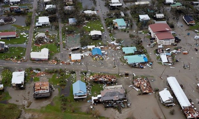
Grand Isle town on the eastern flank of Hurricane Ida. (Photo: Ben Depp/National Geographic)
Keellings and other scientists closely monitored the intensification process of Hurricane Ida. Although hurricanes are systems created by complex interactions between oceanic and atmospheric processes, experts indicate that the way Hurricane Ida formed and evolved is typical of storms associated with climate change. According to Gabriel Vecchi, a professor of geosciences at Princeton University, this is a concerning issue for the coming decades.
Researchers are still trying to understand exactly why some storms intensify so rapidly. Compared to other extreme phenomena like heatwaves, droughts, or wildfires, determining the impact of climate change on individual storms is much more challenging. However, it is clear that global warming is creating conditions conducive to stronger hurricanes.
A study published last year in the Proceedings of the National Academies of Sciences analyzed satellite imagery over the past four decades and found that the likelihood of a storm developing into a Category 3 hurricane or higher increases by about 8% each decade due to the accelerating phenomenon of global warming. Not only does climate change enhance the strength of hurricanes, but it also makes them wetter, resulting in enormous rainfall.
“The mechanism that makes storms wetter in a warming climate is actually quite understandable,” Vecchi explained. “A warmer atmosphere holds more moisture, leading to storms that produce more rain.”
Scientists estimate that for every 1 degree Celsius increase in temperature, the atmosphere can hold an additional 7% moisture. After making landfall in Port Fourchon, Hurricane Ida devastated Louisiana with winds exceeding 274 km/h and rainfall of 38 cm in many areas. Authorities also recorded wave surges of 2.1 meters in several locations along the Louisiana and Mississippi coasts.
Sea level rise due to climate change increases the risk of flooding from storm surges, which form when winds push water from the ocean and land. According to Vecchi, the higher the sea level, the more damaging the storm surges become. Researchers are still unsure whether global warming leads to more frequent rainstorms, but warmer sea surface temperatures are increasing the likelihood of strong storms.
In August 2017, Hurricane Harvey struck the southeastern region of Texas, dumping 152 cm of rain in many areas of Houston and its surroundings. A study published later that year in the Geophysical Review Letters found that rainfall from Hurricane Harvey was 38% higher than what would have been expected without the influence of global warming.
As of now, the rainfall from Hurricane Ida in Louisiana is not as severe as that from Hurricane Harvey, but Ida is projected to move through the Tennessee Valley to the northeastern region in the coming days, with heavy rain being the biggest concern, according to Texas meteorologist John Nielsen-Gammon, a professor of atmospheric sciences at Texas A&M University. Even if the total rainfall does not match that of Hurricane Harvey, areas further inland typically receive lower rainfall, making them less prepared to handle 38 cm of rain in a single day.
The vast lands along the storm’s path, including Tennessee, also experienced a wet summer, meaning higher-than-normal water levels and wetter soil, increasing the risk of flooding. “It’s easy to focus on the center of the storm, but the impacts can extend for miles,” Keellings noted. “As the storm moves into the central United States, through Mississippi, Tennessee, northern Alabama, and Georgia, we need to closely monitor its progression.”


