The Kumano Pluton Acts as a Magnet or Lightning Rod, Attracting Earthquakes in the Region.
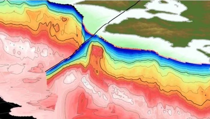
According to Sputnik on February 8, 3D images of the Kumano Pluton rock show that it has redirected tectonic energy to points along its surfaces, where some of the largest earthquakes in the area have occurred.

The Kumano Pluton is the red protruding rock in the 3D image. (Photo: sciencealert).
The high-resolution 3D model reveals that the Pluton is a red protruding rock near the Nankai Subduction Zone, located off the southern coast of Japan. Subduction zones are areas where tectonic plates collide or slide past each other.
Regions above these zones are particularly prone to earthquakes, tsunamis, and volcanic eruptions.
This study marks the first time scientists have been able to identify the entire extent of the Kumano Pluton, which was first discovered in 2006.
The research team compiled seismic data collected over a span of 20 years and processed it using the LoneStar5 supercomputer to frame the high-resolution 3D model of the Pluton.
Shuichi Kodaira, Director of the Japan Agency for Marine-Earth Science and Technology, believes these findings will help them understand whether another major earthquake is forming in the Nankai Subduction Zone.
He stated: “We cannot accurately predict when, where, or the magnitude of future earthquakes, but by combining our models with observational data, we can begin to estimate processes in the near future.”
The 3D model of the Pluton also indicates that it redirects groundwater into the Earth.
Adrien Arnulf, the lead author of the study and a research assistant at the Institute for Geophysics at the University of Texas, described these findings as “eye-opening” and mentioned that they could assist geophysicists in creating 3D images of other seismic points beneath the Earth’s surface.
Regions such as northeastern Japan, New Zealand, and Cascadia in the U.S. Pacific Northwest have other subduction zones, and significant earthquakes have occurred in all of these areas.


