The National Weather Service of the United States predicts that El Niño will weaken in the coming months, making way for the La Niña phenomenon, which could lead to a decrease in global temperatures.
The development of La Niña has significant impacts on weather patterns in the U.S. and around the globe. It can temporarily slow down the global warming trend that began approximately nine months ago when El Niño started to take effect. La Niña is also known for driving stronger hurricane seasons, causing significant destruction in the Atlantic, while increasing drought conditions in Southern California and the Midwest. It tends to cool global temperatures. Although it does not end the prolonged warming of the planet observed over the past decade, La Niña may mitigate the extreme warming levels recently recorded by scientists.

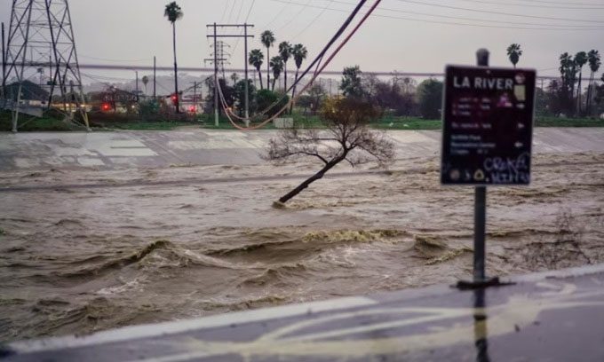
Flooding in Los Angeles on February 5. (Photo: Washington Post).
January 2024 was recorded as the warmest month in Earth’s history. This also marks the eighth consecutive month of record-high temperatures. It signifies the end of a 12-month period during which the planet experienced concerning warming levels of 1.5 degrees Celsius compared to the 19th-century average, before fossil fuel consumption became widespread, according to the European Union’s Copernicus Climate Change Service.
El Niño and La Niña Explained
Earth’s weather is influenced by El Niño or La Niña depending on conditions along the equatorial region of the Pacific Ocean. When trade winds blowing from east to west weaken or even reverse, warm surface waters accumulate in the central and eastern Pacific, leading to the El Niño phenomenon and cascading effects on global weather, including warmer-than-normal conditions in the southern U.S., particularly Southern California, a weakened Atlantic hurricane season, droughts and wildfires in Indonesia, and southern Africa.
Climate Scientists’ Predictions for the Coming Months
On February 8, climate experts at the National Weather Service reported a decrease in warmth in the eastern and central eastern Pacific during January, along with a weakening of the wind patterns associated with El Niño. Meanwhile, climate prediction models indicate that El Niño will continue to weaken during the spring months. There is a 79% chance that “neutral” conditions, lacking both El Niño and La Niña phenomena, will occur between April and June 2024.
The research team emphasized that predicting how El Niño or La Niña will unfold in the spring months can be quite challenging, as the patterns often transition during that time, making trend forecasting more difficult. However, a rapid shift to La Niña is common after a record strong El Niño event, similar to the current El Niño. According to Tom Di Liberto, a climate scientist at the National Oceanic and Atmospheric Administration, similar occurrences were noted during the strong El Niño events of 1982-1983 and 1997-1998.
No matter how quickly it weakens, El Niño is likely to continue influencing global climate patterns for the next few months. “Even though it has passed its peak, it still has an impact,” Di Liberto stated.
Effects of Transitioning to La Niña
Scientists will closely monitor the transition from El Niño’s global warming pattern to La Niña’s cooling effects and how this may impact the average global temperature. This could help answer the crucial question of whether the pace of global warming and climate change is accelerating.
The transition to La Niña could potentially cool global temperatures in 2024 and prevent figures from exceeding those of 2023, further supporting the hypothesis that 2023 marks a stabilization point for global temperatures, according to Gavin Schmidt, director of NASA’s Goddard Space Flight Center.
However, if 2024 ends up being warmer than scientists expect, despite the presence of La Niña, it could provide additional evidence that the system has changed. Climate change also offers more data and opportunities to understand how global warming may influence El Niño and La Niña. Climate scientists do not yet have clear answers, but they suspect that the frequency of strong El Niño and La Niña events will likely increase throughout the coming century.
La Niña Replacing El Niño: What Impact on Vietnam?
For Vietnam, the emergence of La Niña may lead to an increase in storms and tropical depressions. Central and Southern regions will face heavier rainfall and more frequent flooding.

Residents navigating through a flooded area in Chuong My, Hanoi. (Source: AAP).
In an interview with VnExpress in February 2024, Associate Professor Dr. Pham Thi Thanh Nga, director of the Institute of Meteorology, Hydrology, and Climate Change, noted that typical La Niña events occurred in 1998-2000, 2007-2008, 2010-2011, and 2020-2022.
Among them, a severe cold spell lasting 38 days in January-February 2008 resulted in the death of 180,000 hectares of rice and nearly 110,000 livestock, with estimated damages reaching 400 billion VND.
The La Niña period of 2020-2022 also recorded significant damages. In 2020, the country experienced 16 out of 22 types of natural disasters, including 14 storms and tropical depressions; 120 flash floods and landslides; and 265 thunderstorms, whirlwinds, and lightning strikes, resulting in 357 deaths and disappearances, with total damages exceeding 39.96 trillion VND.
In 2022 alone, natural disasters in the country claimed 175 lives and caused economic losses of nearly 19.5 trillion VND.


