A low-pressure area is moving into the East Sea and is expected to strengthen into a tropical depression, potentially developing into a storm. The North and Central regions will see the end of the heatwave starting midweek.
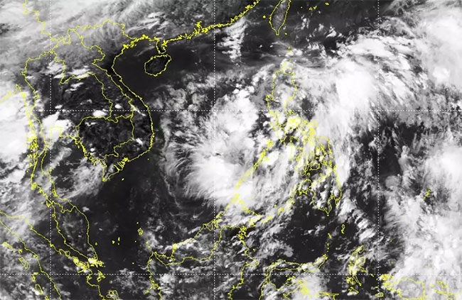
The National Center for Hydro-Meteorological Forecasting has reported that at 7 AM on June 27, a low-pressure area was located at approximately 13.5-14.5 degrees North latitude; 119.5-120.5 degrees East longitude, over the southern part of Luzon Island (Philippines).
From June 29 to July 2, the low-pressure area is likely to strengthen into a tropical depression (TD) with a probability of about 70-80%, and later may intensify into a storm with a probability of 40-60% in the northern part of the East Sea. The National Center for Hydro-Meteorological Forecasting is continuing to monitor this low-pressure area.

Satellite image of the low-pressure area in the Philippines. (Photo: NCHMF)
From the evening of June 29 to July 2, there is a possibility of moderate to heavy rain and thunderstorms in the Northern and North Central regions, with localized heavy downpours expected.
From June 29 to July 3, the Central Highlands and Southern regions may experience showers and thunderstorms, with localized heavy to very heavy rainfall.
There is a need to be cautious of risks such as tornadoes, lightning, hail, and strong winds in the Northern and North Central regions, as well as landslides and flash floods in mountainous areas of these regions, and localized flooding in low-lying areas and along rivers. Additionally, small floods may occur in rivers and streams in the Northern and North Central regions.
Long-term forecasts during the high school graduation exam period (July 6-9) in the Northern region, Central Highlands, and Southern regions indicate the likelihood of rain showers and thunderstorms.
Deputy Director of the National Center for Hydro-Meteorological Forecasting, Hoang Phuc Lam, stated that from now until the end of 2022, it is forecasted that there will be about 10-12 storms and tropical depressions in the East Sea. Among these, 4-6 storms are expected to directly impact the mainland of our country, which is approximately at the long-term average (LTA) for this period.
However, Mr. Lam emphasized the need to be cautious of storms with complex movement patterns, which may occur frequently in the last months of 2022.
From July to September, rainfall in the Northern region is expected to be higher than the LTA. In contrast, the Central Highlands and Southern regions will experience rainfall deficits compared to the LTA.
From around October to November, the coastal areas of Central Vietnam and the Central Highlands are forecasted to have higher rainfall than the LTA. There is a high risk of heavy rainfall occurring in succession. Additionally, caution is advised for dangerous weather phenomena such as thunderstorms, tornadoes, and hail across the country.
Regarding heatwaves, in July, the Northern and Central regions are likely to continue experiencing severe heat with maximum temperatures exceeding 37 degrees Celsius. The Central Highlands and Southern regions from July to September are expected to have average temperatures about 0.5 degrees Celsius higher than the LTA.
Today, the area from Thanh Hoa to Phu Yen is still experiencing hot weather and severe heat with common maximum temperatures ranging from 35-38 degrees Celsius, with some places exceeding 38 degrees. The relative humidity is low, ranging from 45-65%. The time with temperatures above 35 degrees is from 11 AM to 5 PM.
The Northern region is experiencing hot weather, with some places seeing severe heat and maximum temperatures generally between 35-37 degrees, with some areas exceeding 37 degrees. The relative humidity is low, ranging from 50-65%. The time with temperatures above 35 degrees is from 1 PM to 4 PM.
From June 29, the heat is expected to gradually decrease in the Northern region; the Central region may continue to experience heat until June 30.


