 |
|
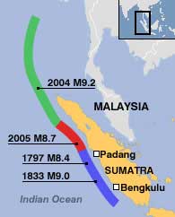
The region at risk of tsunamis is gradually shifting from the north to the south |
An American scientist researching the islands off the southern coast of Sumatra, Indonesia, has reported clear evidence that this area may continue to experience larger earthquakes and tsunamis in the coming decades.
Professor Kerry Sieh is utilizing a global positioning network to monitor the movement of the Earth’s crust near a major fault line that triggered the devastating event last December.
His work indicates that there is still a massive amount of stress accumulating along this fault, which could be released in the near future. Kerry Sieh strongly believes that the cities of Padang and Bengkulu may be the most at risk.
“Time is now diluting such events,” said Kerry Sieh, who is working at the Tectonic Observatory, California Institute of Technology (Caltech).
“I can’t say for sure whether it is happening, but our team continues to tell coastal residents that they must prepare for tsunamis that could occur in the lifetimes of their descendants.”
The earthquake on December 26 last year, measuring 9.2 on the Richter scale, originated from a fault along the boundary between the Indian-Australian and Eurasian tectonic plates, where one plate is pushing against the other. The resulting tsunami caused devastating destruction along the Bay of Bengal, from northern Sumatra to Thailand, Sri Lanka, and India.
 |
|
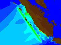
Forecast models predict waves reaching heights of up to 10 meters hitting the two Indonesian cities on Sumatra Island, Padang and Bengkulu |
Following that was an 8.7 magnitude earthquake that occurred in March 2005, farther south compared to the previous earthquake but on the same tectonic boundary.
Sieh indicates that scientists’ concerns are now focused on events further south, towards the Mentawai Islands. This area has experienced significant earthquakes occurring every two centuries, and currently, it is nearing the end of that earthquake cycle.
Professor Stephan Grilli from the University of Rhode Island has modeled the potential tsunami that may occur in this region from an earthquake of 9.2 magnitude, similar to the one that occurred on December 26.
“Our predictions for Padang and Bengkulu to the south indicate that waves could reach heights of up to 10 meters hitting these cities.”
Both Padang and Bengkulu are larger cities than Banda Aceh, which was devastated in the tsunami on December 26 last year. Like Banda Aceh, Padang is situated very low along the coastline.


