Currently, there are two typhoons active both on land and offshore in the Philippines. One of these typhoons is making landfall in the central region of the country and has the potential to enter the South China Sea before moving inland into our territory.
On the morning of September 7, Ms. Le Thi Xuan Lan, former Deputy Head of the Southern Regional Meteorological and Hydrological Forecast Center, reported that observations from Japanese forecasting models indicate that two typhoons are active in the Philippines and offshore.

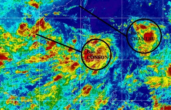
Simulation of the paths of the two typhoons.
Among them, the typhoon currently active in central Philippines is internationally named CONSON. It is expected to enter the South China Sea and move in a west-northwest direction, passing through the Paracel Islands in the next two days.
According to forecasts on the early morning of September 7, after sweeping through the Paracel Islands, this typhoon will continue to move inland into our territory, with predictions indicating it will reach the area of Con Co Island and make landfall in Quang Tri – Hue within the next 3-4 days. However, the storm’s development is complex, and fishermen need to closely monitor the forecasts.
By noon on September 7, forecasting models showed a change in the storm’s direction, now moving northwest, with a trajectory shifted slightly north compared to earlier predictions on the same day. Specifically, the storm will enter the southern part of the Gulf of Tonkin. The area affected by the storm includes provinces from the north of Hai Van Pass and beyond.
Ms. Lan advised that fishing vessels operating in this area should move south and seek shelter in the waters of Nha Trang or Cam Ranh for safety.
Additionally, the other typhoon, internationally named CHANTHU, is expected to reach Taiwan in the next 4-5 days. It will not enter the South China Sea but will strengthen the southwest monsoon, causing rain in our coastal and inland areas.


