A recent landslide along the riverbank in British Columbia has completely blocked the waterway, posing a catastrophic threat to a population of endangered fish trapped on the other side of the river.
Stunning new satellite images reveal that a river in Canada rapidly swelled after a major landslide completely obstructed the waterway. This blockage may have killed a threatened salmon population by preventing these fish from reaching their upstream spawning grounds following the sudden water damming.

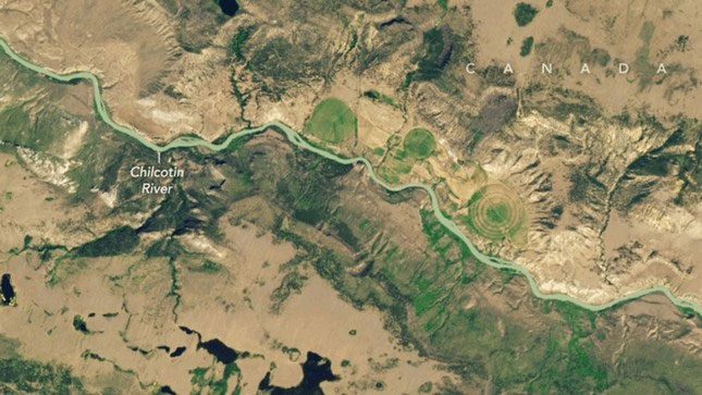
Satellite images of the Chilcotin River taken by Landsat 9 before the landslide (July 16) and after the landslide (August 1) show the rising river levels following the damming. (Image: NASA Earth Observatory/Wanmei Liang/Landsat).
The major landslide occurred late on July 30 near Farwell Canyon on the southern bank of the Chilcotin River—a 240 km long tributary of the Fraser River. The landslide happened about 22 km upstream from where the Chilcotin meets the Fraser River, dumping approximately 18 million cubic meters of earth and rock into the waterway and completely blocking its flow, according to an emergency statement from the British Columbia government.
Within less than 48 hours, the river’s water level rose significantly, breaching the banks at several points and forming a debris-filled reservoir behind the blockage, NASA Earth Observatory images show. The section of the Chilcotin River between the landslide and the Fraser River was nearly completely dry.
Local authorities swiftly issued an evacuation order for residents living downstream of the blockage, fearing that the rock dam could ultimately break and release a surge of water that might cause flash floods or trigger further landslides downstream. It is unclear how many people were evacuated.

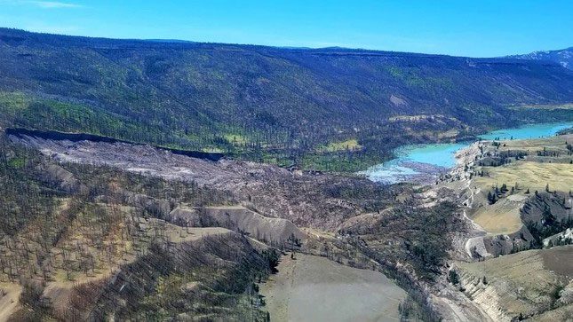
By August 5, no water was flowing through the remaining debris after the landslide. (Image: Province of British Columbia).
On August 5, part of the dam finally broke, releasing a torrent of water flowing through the previously dry riverbed. Although the water rushed at a rate of over 3,500 cubic meters per second, the surge did not cause any major damage.
However, according to a statement from the Tŝilhqot’in Nation, the landslide could significantly impact the sockeye salmon (Oncorhynchus nerka) population residing in the river, with many of them likely being downstream at the time of the landslide.
Not only are some fish likely to die after becoming stranded and suffocating in the dry river section, but any surviving fish in the Fraser River will now face much greater challenges in reaching their spawning grounds in Taseko Lake—approximately 72 km upstream—according to NASA Earth Observatory.
Subsequent satellite images released by NASA Earth Observatory show that the changes in the flow of the Chilcotin River have caused a large amount of sediment to wash away from the riverbed, turning the waterway and the Fraser River a brownish-yellow color. Although this effect is only temporary, the changes in water quality could further impact freshwater species downstream.


