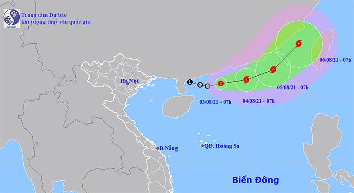
According to the National Center for Hydro-Meteorological Forecasting, at 7 AM on August 3, the center of the tropical depression was located at approximately 21.1 degrees North latitude and 113.1 degrees East longitude, right over the southern sea area of Guangdong Province (China). The strongest winds near the center of the tropical depression were at level 6 (40-50 km/h), with gusts up to level 8. The radius of strong winds at level 6, with gusts at level 8, was about 70 km from the center of the tropical depression.
Forecast for the next 24 hours: The tropical depression is moving in a northeast direction at about 10 km per hour and is likely to strengthen into a storm. By 7 AM on August 4, the storm’s center will be located at approximately 21.4 degrees North latitude and 115.1 degrees East longitude, about 140 km southeast of Hong Kong (China). The strongest winds near the storm’s center will be at level 8 (60-75 km/h), with gusts up to level 10.

Location and movement direction of the tropical depression. (Photo: NCHMF).
Thunderstorms and Strong Winds at Sea
Due to the influence of the tropical depression, there will be thunderstorms in the northern sea area of the North East Sea, with strong winds of level 6 near the center of the tropical depression, gusting to level 8; sea waves will reach heights of 2-3 meters, causing rough seas.
Additionally, due to the influence of the southwest monsoon, from today, August 3, to August 7, in the sea area from Binh Dinh to Ca Mau, as well as the northern and central parts of the East Sea (including the waters of the Paracel Islands and the northern waters of the Spratly Islands), strong southwest winds of level 6, gusting to levels 7-8 are expected; sea waves will be 2-4 meters high, causing rough seas.
Dangerous areas in the East Sea over the next 24 hours (with strong winds from level 6, gusting from level 8 or higher): North of latitude 19.5 degrees North; east of longitude 111.0 degrees East. All vessels operating in the dangerous areas are at high risk of being affected by strong winds, high waves, and whirlwinds.
In the next 24 to 48 hours, the storm will continue moving northeast at a speed of 10-15 km per hour and is likely to strengthen further. By 7 AM on August 5, the storm’s center will be located at approximately 22.2 degrees North latitude and 117.2 degrees East longitude, about 330 km southeast of Hong Kong. The strongest winds near the storm’s center will reach level 9 (75-90 km/h), with gusts up to level 11.
In the next 48 to 72 hours, the storm will continue to move northeast at a speed of 15-20 km per hour.
The disaster risk warning level for the northern sea area of the North East Sea is level 3.
Heat Wave in the Northern and Central Regions
Forecasts indicate that due to the influence of the southwest winds causing a foehn effect combined with upper-level divergence, on August 3, the Central region will experience heat and severe heat, with some areas experiencing extreme heat with maximum temperatures ranging from 35-38 degrees Celsius, and some areas exceeding 39 degrees. The Northern region will also experience heat, with some areas facing severe heat and maximum temperatures ranging from 35-37 degrees Celsius, and some areas exceeding 37 degrees.
The relative humidity during the day is expected to be between 45-60%. The duration of temperatures above 35 degrees is expected to occur from 10 AM to 5 PM.
In Hanoi, on August 3, there will be heat, with some areas experiencing severe heat and maximum temperatures ranging from 35-37 degrees, and some areas exceeding 37 degrees.
Heat warnings in the Northern region are expected to last for about 3-4 days; in the Central region, the heat will persist for several more days.


