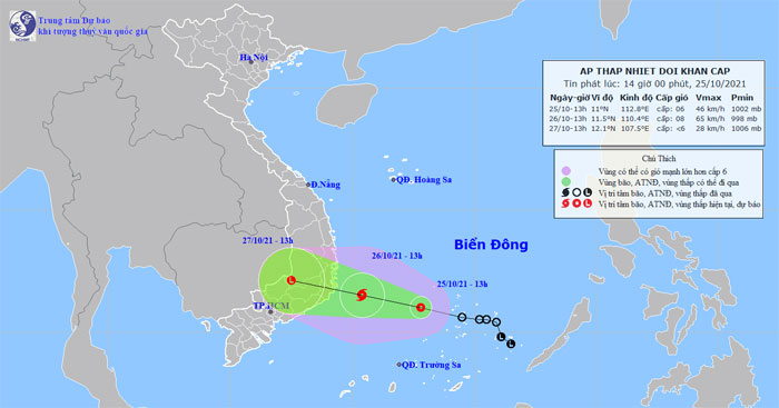
A tropical depression is currently intensifying to level 6 with gusts of level 8 and is expected to move in a west-northwest direction, potentially strengthening into a storm as it approaches the Khánh Hòa – Ninh Thuận area.
According to the National Center for Hydro-Meteorological Forecasting, at 1 PM on October 25, the center of the tropical depression was located at approximately 11.0 degrees North latitude and 112.8 degrees East longitude, about 180 km southwest of Song Tu Tay Island. The strongest winds near the center of the tropical depression are at level 6 (40-50 km/h), with gusts reaching level 8. The radius of strong winds at level 6 and gusts of level 8 extends about 80 km from the center of the tropical depression.

Projected path of the tropical depression.
Forecast for the next 24 hours: The tropical depression is expected to move mainly in a west-northwest direction, traveling at about 10-15 km per hour, with the possibility of strengthening into a storm. By 1 PM on October 26, the center of the storm is expected to be located at about 11.5 degrees North latitude and 110.4 degrees East longitude, approximately 160 km from the coast of Khánh Hòa and about 140 km from the coast of Ninh Thuận. The strongest winds near the center of the storm will be at level 8 (60-75 km/h), with gusts reaching level 10.
Danger zones in the East Sea for the next 24 hours (winds of level 6 or higher, gusts of level 8 or higher): from latitude 9.0 to 13.0 degrees North; west of longitude 114.5 degrees East. All vessels operating in the danger zone are at high risk of being affected by strong gusts and large waves. Disaster risk warning level: 3.
In the next 24 to 48 hours, the storm will continue to move mainly in a west-northwest direction at about 15 km per hour, gradually weakening into a tropical depression as it enters the area from Khánh Hòa to Bình Thuận, and then weakening into a low-pressure area over the southern Central Highlands. The strongest winds in the center of the low-pressure area will decrease to below level 6 (below 40 km/h).
Danger zones in the East Sea for the next 24-48 hours (winds of level 6 or higher, gusts of level 8 or higher): from latitude 10.0 to 14.0 degrees North; west of longitude 112.0 degrees East. All vessels operating in the danger zone are at high risk of being affected by strong gusts and large waves. Disaster risk warning level: 3.
Warning of strong winds and large waves at sea: In the central East Sea area (including the waters north of the Spratly Islands), winds will be strong at level 6, increasing to level 7, near the storm center reaching level 8, with gusts up to level 10; wave heights will range from 2.0 to 4.0 meters, with very rough seas; in the northern East Sea area (including the waters around the Paracel Islands) and the waters from Quảng Trị to Khánh Hòa, northeast winds will be strong at level 6, with gusts of level 7-8; wave heights will range from 2.0 to 4.0 meters, with rough seas.
Additionally, in the central and southern East Sea areas (including the waters around the Spratly Islands), the waters from Quảng Trị to Khánh Hòa will experience heavy rain and thunderstorms. During thunderstorms, tornadoes and strong gusts may occur.
Heavy rain warning
From tomorrow (October 26) until the end of October 27, the area from Thừa Thiên Huế to Bình Thuận, the Central Highlands, and southeastern regions will experience heavy to very heavy rainfall, with forecasted rainfall: from Thừa Thiên Huế to Quảng Ngãi, Bình Thuận, northern Central Highlands, and southeastern regions: 100-200 mm, with some places exceeding 200 mm; from Bình Định to Ninh Thuận and southern Central Highlands: 150-250 mm, with some places exceeding 300 mm.
From October 27 to 30, the northern Central Coast and central regions will experience heavy rain, with some areas facing very heavy rainfall due to the influence of cold air and east wind disturbances.


