This morning, August 9, the center of the tropical depression (TD) is located over the Paracel Islands with maximum winds near the center reaching level 6, gusting to level 8.
At a meeting this morning regarding the response to the tropical depression, Mr. Hoang Phuc Lam, Deputy Director of the National Center for Meteorological and Hydrological Forecasting, stated that it is highly likely that today the tropical depression will strengthen into a storm. This will be the second storm in the South China Sea this year.
According to Mr. Lam, the storm’s organization is not yet stable, so the areas of thunderstorms and heavy rain are still quite far to the west, which is why many areas in Central Vietnam experienced heavy rain on the night of August 8.
Due to the thunderstorms, there are very strong gusts of wind in the areas with thunderstorms over the sea.
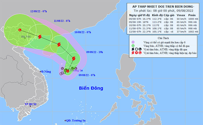
Forecast for today, August 9, the tropical depression is likely to strengthen into a storm. (Photo: National Meteorological Center)
Mr. Lam also mentioned that once the storm stabilizes, it will move northward, likely making landfall on Leizhou Island, north of Hainan Island (China). As it passes Leizhou Island, the storm will weaken slightly, but will strengthen again as it moves into the Gulf of Tonkin.
“We assess that this storm will mainly maintain levels 8-9. In the Gulf of Tonkin, starting tomorrow, strong winds of level 6 will occur, and as the storm approaches, winds will strengthen to level 8, gusting to level 10. Today, Central Vietnam will still have rain, but it will significantly decrease tomorrow, with rain shifting to the northern region. Rain will concentrate in the northern area on August 10 and 11,” Mr. Lam stated.
Mr. Nguyen Van Tien, Deputy General Director of the General Department of Disaster Prevention and Control (Ministry of Agriculture and Rural Development), reported that since the night of August 8, due to the influence of the southwest monsoon and the tropical depression, five fishing vessels have been damaged, with two sinking. Currently, rescue operations are underway by the relevant authorities.
In light of these developments, the National Steering Committee for Disaster Prevention and Control issued a telegram at 7:30 AM today and held a meeting to implement response measures, particularly emphasizing the need to call boats into safe shelters. The border guard and fisheries forces have been tasked with coordinating with the Meteorological and Hydrological Forecasting Center to provide specific guidance on the safest routes for vessel operators.
“We also warn localities in the northern region, especially in the Northeast, to prepare plans to respond to the storm’s circulation, which may cause rain, flooding, and landslides,” Mr. Tien emphasized.


